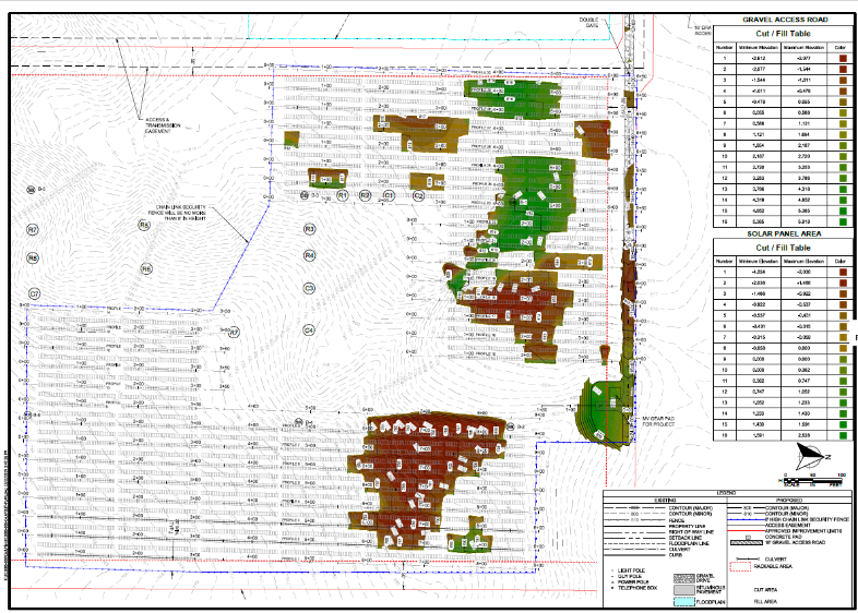
WSB’s Renewable Energy Solar team continues to innovate in the industry and expand our expertise. Most recently we developed a system to quickly and efficiently analyze and compare solar site grading costs. Even a 6” cut or fill across a large site can result in substantial costs making a site less attractive, or impractical, for a developer. Analyzing rows and rows of solar panels conventionally has been tedious and time consuming. Our new, automated CAD processes makes the analysis more efficient and cost-effective.
Methodology
The automated processes uses Civil3D. It allows the user to input tolerances from different panel types and desired racking lengths to generate a proposed grading surface. The system produces a thematic mapping of grading cut and fill quantities for areas within the array footprint on a micro level.
Analysis & Results
As solar developers know, site grading costs can make or break a project. Being able to quickly and efficiently apply this technology to small and large sites allows a developer to compare, evaluate and determine which sites are most cost-effective from a grading standpoint. We can further refine array layouts to efficiently and cost-effectively fit within the site terrain, minimizing the amount of site grading required.
Similar technology takes structural pile plans and produces a plan and point file of X, Y, and Z coordinates. That information can be downloaded to the surveyor, in the field, to pinpoint the exact location and elevation of each individual pile in a project, anything from 1 MWac sites to 500 MWac sites and larger.
Geography
As a national company, WSB can apply this process to any site around the country. Our Renewable Energy team has worked on renewable energy projects across the country and can provide a full set of services for solar projects; services include, but are not limited to, Critical Issues Analysis (CIA), Engineering and Site Planning Approvals, Construction Surveying, and Geotechnical Services.
What’s next?
WSB continues to develop techniques and solutions to ensure the success of client projects. From Site Selection software to automated Micro-Grading Analysis, WSB continues to innovate and lead the Renewables market.
Jeff is a licensed Civil Engineer and Senior Project Manager at WSB. He has over 26 years of engineering experience in the areas of municipal, commercial development, and consulting engineering. Jeff has worked with many municipalities and has a wealth of experience in working with local, State, and Federal permitting authorities.
As New
Year’s Day begins to fade and we launch full steam into 2020, I take the
opportunity to reflect on my time as a City Administrator in cities both large
and small as well as discuss with colleagues those things administrators & managers
should be mindful of at the start of each year.
The following are five areas of importance that municipal executives
should consider.
Strategic & Comprehensive Plan
Most
organizations have a strategic or comprehensive plan. These can be extensive and far reaching with
a mission, values, goals, and implementation strategies set by the council, board,
staff, and strategic stakeholders, or they can simply be a short list of
priorities the council has established.
If a community or organization does not have clear direction, the city
administrator should first consider finding the best way to accomplish setting
a clear direction. This is something
that the Mayor of Oakdale and I made a priority, especially when new
councilmembers and staff were introduced into the organization.
Once in
place, it is the role of the administrator and manager to implement the
plan. At the beginning of each year, one
should consider how the plan for the previous year has gone, how and what the
organization will need to implement the current year’s plan and start looking
toward the creation and implementation of next year’s plan.
The
beginning of each new year is an opportunity to reflect upon the past, evaluate
the present, and prepare for the future.
New Councilmembers
The
beginning of a new year often brings changes to the council and board. New members can feel excitement for their new
role as well an overwhelming feeling of uncertainty. It is imperative that administrators and managers
help guide and assist newly elected officials toward success in their new role. Remembering that this could mean different
things to each person and building a relationship with individuals is the key
to deciphering how best to connect and communicate with them.
Provide the
opportunity for success by connecting with each individual and guiding them toward
team, organizational, and personal achievement.
Budget Process
As with
strategic planning, the beginning of the year is the time to start laying the
groundwork for the next budget.
Budgeting is truly a year-round process.
Once the annual budget is adopted in December, there is a short break
and the process begins again early in the year.
Utilizing the strategic and comprehensive plans in planning and crafting
the budget process for the year is imperative.
These documents provide the priorities of the council and board, and identify
investments being considered. During my
time in Oakdale, the finance director and I would meet with each department
head to strategize how best to incorporate the short-term needs of each
department with the long-term goals of the council.
Ensure
successful budget preparation by planning and crafting a framework for the process
and incorporating strategic & comprehensive plans and goals.
Legislative Session & Priorities
With each
new year comes a new Legislative Session and the opportunity for municipalities
to advocate on behalf of priorities and projects of importance. Having a relationship and building a
connection with the Senators and House Members that represent your area is
vital. Being able to work with them
toward the passage of those priorities and projects is essential. They want to work on behalf of their
constituents, so help them by having a list of priorities ready that they will
advocate for. Another valuable resource
in this area is the League of Minnesota Cities (LMC). Work with the LMC on your list and how to
advocate with your Legislators.
Throughout my career, I have been part of the LMC’s policy committee
process. Consider taking advantage of this
opportunity to have a voice in the legislative process for city issues.
Having a
relationship and connection with your state elected officials, the LMC, and a
list of priorities ready for them to advocate on your behalf is an important
piece of the annual thought process for an administrator and manager.
Relationships & Connections
At the
beginning of each year, take stock of and lean into those connections and
relationships that will be vital to the success of the organization and you as
a professional. These might include
connecting with county or surrounding municipal partners, key business or
non-profit community contacts, state or federal elected officials, professional
organizations such as the LMC, Association of Minnesota Counties, or the Minnesota
City/County Managers Association. And do
not forget your family, friends, and neighbors who are invaluable in keeping
you grounded and connected. There have
been many times when I have taken the opportunity to “bounce” thoughts and
ideas off friends and neighbors to gather feedback even if they will not be the
ones directly affected.
The value of
connections and relationships at the professional and personal levels cannot be
overstated. Be strategic about fostering
these relationships now for a successful year.
Conclusion
Creating
plans, budgets, legislative priorities, integrating new councilmembers, and
leaning into relationships & connections is an ongoing process; however, taking
the opportunity to focus on them at the beginning of each year is an important
aspect of municipal leadership and management.
What kind of things do you find essential to focus on in the first quarter of the year? Comment below or message me to learn more about how WSB is helping communities achieve their vision and goals.
Bart has been a City Administrator/Manager in the public sector for over 16 years. He is a strategic leader known for relationship development and connecting people around common themes and goals. Bart’s experience lies in leading and creating an organizational culture of collaboration where the whole becomes greater than the sum of its parts.
Update: Metropolitan Council has extended their 2020 Regional Solicitation grant submittal deadline to May 15 in response to COVID-19.
The Metropolitan Council is now accepting grant applications for the Twin Cities and 7-County Metro area. Here are tips to help you through the process:
$180 million of federal funding is available for projects to be constructed in 2024 or 2025
Eligible project types include roadway, bridge, transit, and bicycle and pedestrian facilities
20 percent local match is required
Funding is for construction only; design and right-of-way are ineligible
Projects must be consistent with local comprehensive plans and Metropolitan Council plans
Applicants must have an approved Americans with Disabilities Act (ADA) transition plan
Applications are due April 16
WSB has a long history of preparing successful Metropolitan Council Regional Solicitation applications. Our team can identify key projects and determine community goals. Additional information about the 2020 regional solicitation requirements can be found here. For further details, contact Scott Mareck at 320.534.5948 or [email protected].
As the world continues to evolve through the advancement of technology, new opportunities and challenges arise that you may, or may not, know the best way to tackle. Staying abreast of new systems and solutions can be a daunting, even overwhelming, task.
At WSB, we use Geographic Information Systems (GIS) to improve the way organizations acquire, understand and use their data. A successful GIS program employs geospatial technology to improve the quality of services, positively impact the decision-making of a community, become a central location for all data and improve overall workflow. To help simplify it for you, we will share some of the most common issues that we encounter and provide some advice on how to handle them.
Unable to retrieve data quickly enough
A properly designed and managed GIS will allow you access to all your organizations information at the touch of a button. Through field to office integration software, your team can enter field data directly from the site of the work and make the data immediately available to you. If you need to be able to verify a critical utility repair in order to calm concerned residents, your team can document the nature of the problem, how and when it was repaired, and include supporting photos or documents.
Unable to locate needed documents
It is time to go paperless. There is no need to continue to store paper documents in your office. They take up unnecessary space, get disorganized and go missing. Have you ever needed to find an as-built in order to verify the location of utility lines and been unable to find the final version? Using a GIS will allow you to convert all your supporting documents into digital files, tag them to any relevant accounts or locations for easy retrieval, and support a greener way of conducting business.
My data is outdated
Using ledgers and spreadsheets to manage your data quickly becomes tedious, time consuming and inefficient. If your system for tracking data involves any of these methods, it is likely current data has not been entered more than once. Imagine you need to share results of a lift station’s most recent inspection, but the most current document you can find is 3 years old. This could create a serious problem if you are unable to provide accurate findings. To ensure your group is working with the most accurate data available, a GIS is an easy and organized way to allow anyone the ability to enter information, keep it all stored in one central location, and control access to sensitive data.
My team is not able to work together efficiently
Do you have people working from more than one location? Do you often find you are emailing the same spreadsheet to multiple people to add data? There must be a more efficient way for your team to work together, right? A GIS can allow everyone on your team the ability to access, edit, and report from your groups database without wondering which version is the most up to date. It can save you time and frustration, allowing your group to spend their valuable time on other projects.
Our GIS group has worked with many clients to find solutions to their data problems. If you find yourself wondering if there might be a better way, please contact us. We will help to determine which of our complimentary, introductory services can improve how your organization works.
Justin leads the GIS Solutions Team. He is an accomplished Solutions Architect with a broad subject matter and technical experience in enterprise GIS and asset management technology. Justin has over 12 years of experience in the GIS field and holds a Master of Geographic Information Science degree from the University of Minnesota.
Minneapolis,
Minn. – Local engineering firm WSB today announced the
promotion of Kian Sabeti to vice president of strategy – a new leadership role
for the rapidly growing Minneapolis-based company. Sabeti will oversee growth
strategies for the firm’s transportation and construction services, ensuring
WSB is able to meet client needs today and in the future.
“Kian is an innovative, dynamic and trusted leader both internally within our entire organization and externally with our clients and partners,” said Bret Weiss, WSB’s president and CEO. “She has already contributed so much to our clients’ success and we are grateful for her continued leadership and insights at WSB.”
Sabeti brings more than 25
years of experience delivering transportation projects from concept development
through completion. She is a trusted consultant for the Minnesota Department of
Transportation and other local agencies. She also managed a team that brought
the first autonomous vehicle to Minnesota for winter weather testing. Since
joining WSB four years ago, Sabeti has mentored many staff members, driven
strategic planning and played a key role in establishing WSB with prospective
transportation clients.
“Transportation is a rapidly
changing industry, so we must be strategic about how we approach new
opportunities and technologies,” said Jon Chiglo, WSB’s chief operating
officer. “Kian will provide an increased focus to our work and ensure we have better
alignment across our many services.”
As a city leader you are responsible for many things;
managing budgets, people, community needs, city assets, and the list goes on. What
if there were a system in place for managing one of your largest assets, the
city streets?
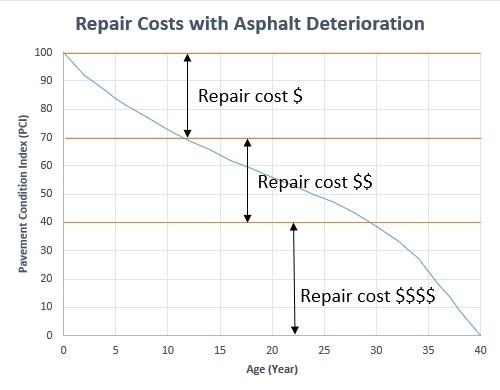
A pavement management program provides a systematic method
of inspecting and rating the pavement condition of your roads; including the
analysis of various maintenance and rehabilitation strategies. As part of the
program, we use pavement forensics to identify the pavement structure and
condition underneath the visible surface of the pavement. We look at the depths
and condition of the pavement layers, signs of bonding or de-bonding, and
distresses that may not be visible from the surface. Data collected from the
pavement cores during forensics, provides a better understanding of the roadway
sections and allows us to determine cost-effective and appropriate pavement
rehabilitation techniques. The program is designed to help you get the most out
of your available resources.
The collected data is used to evaluate funding needs and, in
some cases, implement new funding tools such as franchise fees. We conduct
analysis on various budget scenarios to help you forecast the funding required
to maintain your network of roadways. The inspection results are useful for
talking with residents and City Council Members regarding necessary road
improvements and are vital in justifying the funding needed to maintain city
streets as part of your Capital Improvement Plans.
A thorough pavement management plan can save you from expensive, and sometimes unnecessary, repairs. The data can help you to narrow down the areas that require preventive maintenance and rehabilitation. An effective program will emphasize maintaining streets that are in good condition to extend their service life, as preventive maintenance is less costly than rehabilitation.
However, when streets have deteriorated and demand more extensive repair, your pavement management program allows you to plan for those projects and minimize the risks of having to make extensive changes to the project. By successfully implementing a pavement management program, you can improve the overall performance and life of your roads, saving the city and taxpayers time and money.
Sheue Torng Lee started her career at MnDOT in the MnROAD section after graduation, where she was involved in research data analysis as well as helping MnROAD in developing technical report documents. Sheue works in pavement/asset management and pavement preventative maintenance, emphasizing in pavement design and forensics.
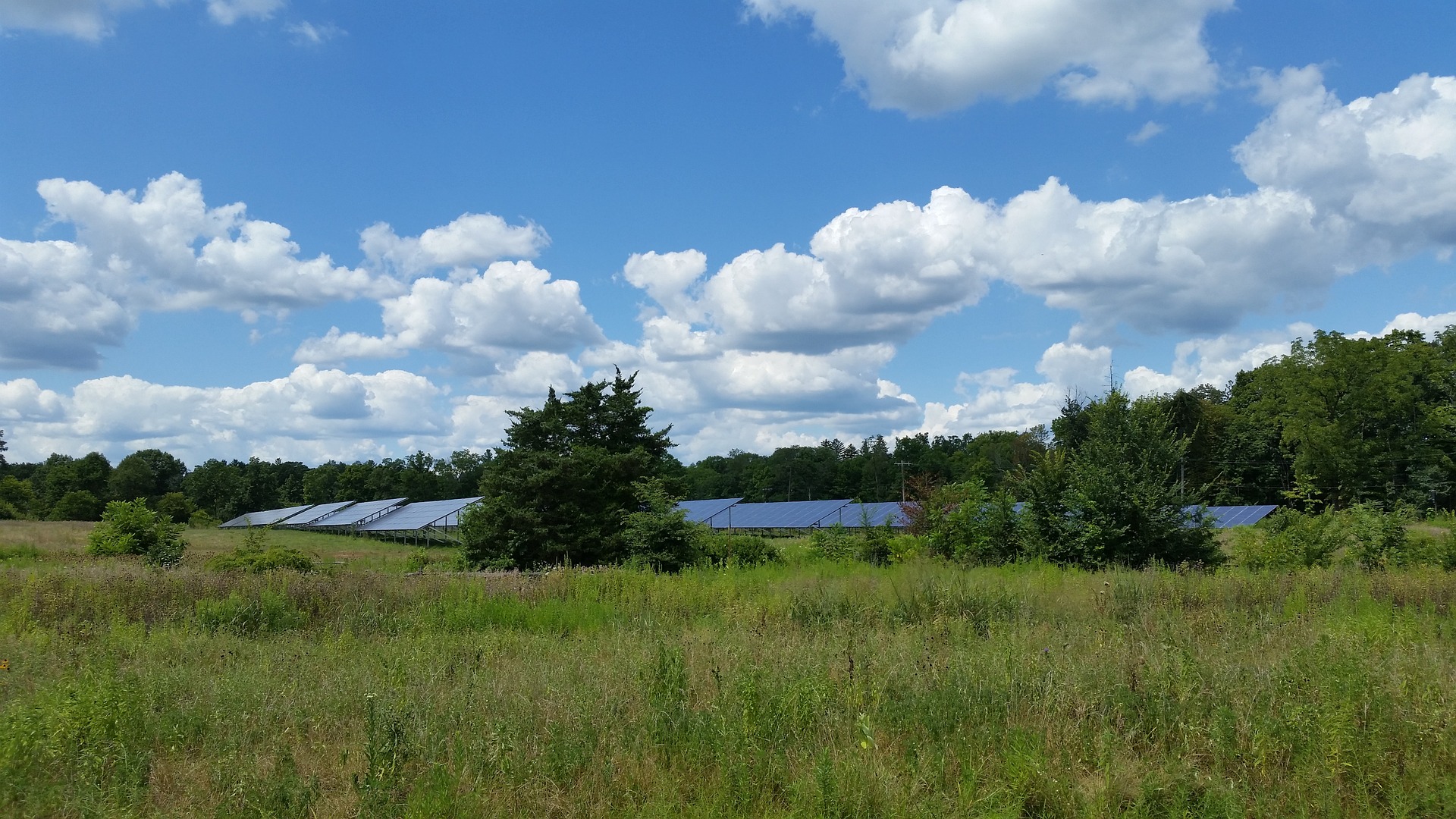
Solar production in Minnesota has seen dramatic increases in the past few years and continues to grow across the state. With this rapid growth comes challenges about how to regulate the installation of panels at a local level. According to the Solar Energy Industries Association (SEIA), Minnesota has already invested $1.9 billion on solar and additional growth is projected at 834 megawatts over the next five years. The installations of solar “farms”, vast arrays of solar panels, can be seen throughout the state and can generate up to a megawatt of electricity each. Development of these sites often requires large, vacant parcels which may also support natural habitats such as wetlands.
The development application process for these solar farms can be challenging for municipalities, especially those who act as the local government unit (LGU) for the Wetland Conservation Act (WCA). Developers must work collaboratively with LGUs to demonstrate a sequencing process that shows how their projects are avoiding, minimizing, and if necessary, replacing unavoidable wetland impacts. Under the WCA rule, the installation of posts and pilings from solar panels has traditionally not been considered a wetland impact if they do not significantly alter the wetland function and value. But, as the solar industry grows, LGUs have had questions about whether the installation of solar panels may lead to loss in wetland quality over time which would be a violation of WCA. A strong measure of wetland quality comes from the diversity of the plants within the wetland, factors like shading from panels and disturbances from construction may lead to conversion of the wetland vegetative community, and subsequently, the wetland quality. Loss of wetlands and wetland quality has overlapping effects on drinking water, lake and stream health, native wildlife, soil heath, and pollinators, all of which are important to our Minnesota ecosystems.
So why does this affect you? Many municipalities act as the
LGU responsible for implementing WCA. LGUs, alongside other regulating
agencies, have been struggling to make impact determinations for sites that
install panels in wetlands because there is little data available that
addresses the future outcomes of these natural areas. There is a growing need
for baseline data about how the quality of wetland vegetation changes
throughout the solar development process. If data were available, LGUs could
use these as a basis for making determinations.
Having baseline data about wetland vegetative quality under
solar panels is beneficial to both regulators and developers. Regulators will
have a scientific basis for making wetland impact determinations within their
jurisdiction and developers will see more consistency across municipalities
during the permitting process. We may see that wetland quality improves under
solar panels in certain circumstances through the planting of native vegetation
upon completion of development. In other scenarios, wetland quality may
decrease if the existing wetland was of higher quality prior to development.
WSB has started an exciting initiative to collect this baseline data at various solar sites in Minnesota. In 2019, environmental scientists at WSB surveyed wetland vegetation under existing or planned solar panels at four solar farms in varying stages of development. Additional data collection at these sites is planned for the summer of 2020. WSB is in the process of developing a Legislative-Citizen Commission on Minnesota Resources (LCCMR) grant application to expand this research in 2021 to more sites across the state and to include other metrics that may influence vegetation such as fixed-tilt or tracker panel types. Support of this research from municipalities will be important for the LCCMR application process and we encourage you to join us in the process through letters of support, in-kind hours, monetary support, or providing access to solar farms within your area. It is an exciting time in the renewable energy industry and WSB is committed to helping advance the clean energy market in a way that is sustainable to our Minnesota environment that we all cherish.
Roxy is an environmental scientist and certified wetland delineator. She has a master’s degree in ecology and is a Certified Associate Ecologist. She has completed numerous wetland delineations and has experience with wetland monitoring, ecological restoration design, environmental site assessments, field research, biological surveys, ArcGIS mapping, and GPS Trimble.
Road reconstruction projects
affect residents of all cities, from large metropolitan areas to small rural centers.
While residents are very familiar with the sight of bright orange cones and
excavating machines that are shown for a few months in the summer, few know the
full amount of work that goes into improving roads and public utilities the
rest of the year. Here is a season by season breakdown of how a road
reconstruction project comes to life:
Summer/Fall
The summer/fall season is when work on a specific project typically begins for the upcoming construction season, with the start of preliminary design. Depending on the size and complexity of the project, preliminary design can begin months or even years earlier than this time frame.
The preliminary design begins by collecting extensive information on the existing conditions of the public infrastructure in the project area. This can be done through a topographic survey of the area, taking geotechnical readings on the materials in the area, and even reviewing asset management systems or old plan sets for the project area.
Based on the information gathered, the project team (typically consisting of transportation and municipal engineers) can identify improvements needed within the project area. The team then provides a preliminary overview of proposed improvements to the project owners, private utility companies such as gas or electric that could be impacted, residents, business owners and other stakeholders in the project area. At this point, public engagement becomes critical to connect with the owners, companies, and residents to solicit feedback on the proposed improvements and gather additional information on existing conditions. This feedback can be achieved through neighborhood meetings, showcasing visualizations, and conducting community surveys.
After gathering
feedback, the project team presents the proposed infrastructure improvements along
with estimates on costs and schedule to the project owners, and, if the project
is still supported, begins final design.
Fall/Winter
The fall/winter season is dedicated to final design of the project. The team (supported by site & landscape designers, water resource engineers and wastewater engineers) completes final design documents that specialists in infrastructure construction techniques will use build the project. These documents will complete the city’s vision for the project while ensuring it is properly engineered and safe for residents. The design includes not only the pavement that residents drive on, but also all of the public utilities in the project area, such as storm sewer, sanitary sewer and watermain.
During this time, the project will also be reviewed by permitting agencies that have jurisdiction over certain aspects of the project. These agencies, such as a county or state transportation agency, may have jurisdiction over neighboring roads. Other agencies, like a state departments of natural resources, may review the project for environmental regulations within the project area.
Once the plans and specifications are complete, the project team will share the finished design documents with the project owner. The project is then authorized to be bid for construction.
Winter/Spring
The spring season is
used to bid the project and prepare for construction. After the project is authorized
to be bid, a notice goes out to contractors notifying them of the project and
providing them access to the plans and specifications. If a contractor is
interested in constructing the project, they submit a set of documents to the
project owner. These documents include insurance information, proof of bonds,
and their bid of how much they believe it will cost to construct the project.
At an arranged time, a contractor will be selected from those that submitted a
bid.
Once a contractor has been selected, project management and construction administration begins. Preliminary construction meetings are held with the project owners, the project team, and other stakeholders, to prepare for the upcoming construction of the project.
Spring/Summer
After the preliminary and final designs are complete, construction -the most visible stage of a project – can begin during the spring/summer season. During this time, the project team monitors contractor progress on the project, and ensures that the construction is being done according to the plans and specifications that were prepared in the fall/winter. This monitoring consists of a variety of activities that include construction material testing, environmental compliance, and more.
Because the winter season is often the longest in the Midwest, the time frame for construction is extremely short. To protect the final product, some projects require contractors to wait until after winter to finish minor paving and restoration work during the following spring/summer season.
Once all of the work is complete and accepted by the project owner, the contract is finalized and closed out. Usually a maintenance period is required of the contractor, during which time they are responsible to address any workmanship or materials defects which are identified following close out.
At this point, the project is considered complete. The project owner is responsible for ongoing maintenance and repair of the infrastructure through their Public Works Department. The new seasonal cycle begins with the next project that was prioritized or identified within that community’s Capital Improvement Plan or similar planning document. Learn about how WSB can assist your community with any or all of these project cycles by visiting https://www.wsbeng.com/expertise/community/ or clicking on any of the linked services above.
Brandon is a Graduate Engineer with WSB and serves as the assistant city engineer for the City of Sunfish Lake, MN. He is experienced with reviewing developer and residential land development plans and management of cities’ Municipal State Aid Systems (MSAS) through the Minnesota Department of Transportation (MnDOT).
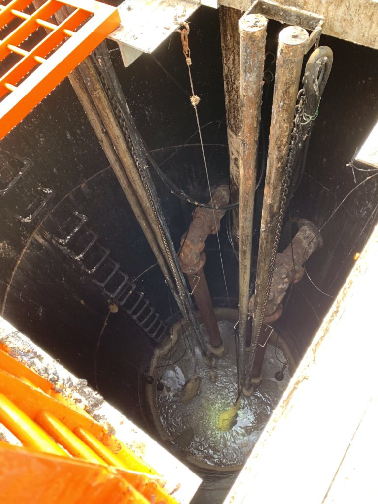
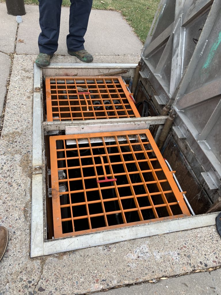
As infrastructure ages, you will need to prioritize which items to fix first. You need to determine which items to do this year and which items can wait for future plans. How do you know when it is time to put a lift station at the top of the list? Below are 5 signs that your lift station is nearing the end of their usable life cycle.
1. Clogged Pumps – Have your maintenance crews been spending an inordinate amount of time and resources addressing clogged pumps? Rags, sanitary products, and many other items find their way into your city’s sanitary sewer, but cannot be passed by the old style impellers. It might be time to upgrade your pumps to modern non-clog impellers to address this maintenance nightmare.
2. Increased Pump Runtimes – Over time, pumps lose their efficiency causing them to generate less flow at lower velocities. This can cause solids to settle in the forcemain and exacerbate the pump inefficiencies. Compare your electricity bills over time. If the number of kilowatt hours used has gone up, it might be time to dig into the issue.
3. Electrical & Communication Failures – Old starters, leaking mechanical seals, electrical service changes: these items can cause tripped circuit breakers and blown fuses. If your SCADA system isn’t communicating these failures to maintenance staff, you might find out from an angry resident with sewage backup in their basement. Electrical and communication upgrades will help your staff maintain real-time status updates and put your mind at ease.
4. Degraded Concrete, Piping & Equipment – Sanitary sewage can generate corrosive hydrogen sulfide (H2S) gas that chews up the lift station concrete, pump rails, piping, hatches, and valves. Ensuring proper pump cycles and providing mixing to break up gas producing materials in the lift station can help reduce gas generation, but it may also be necessary to coat the concrete with a corrosion resistant barrier and replace lift station equipment with more robust materials. Have the field crew take photos for you to review.
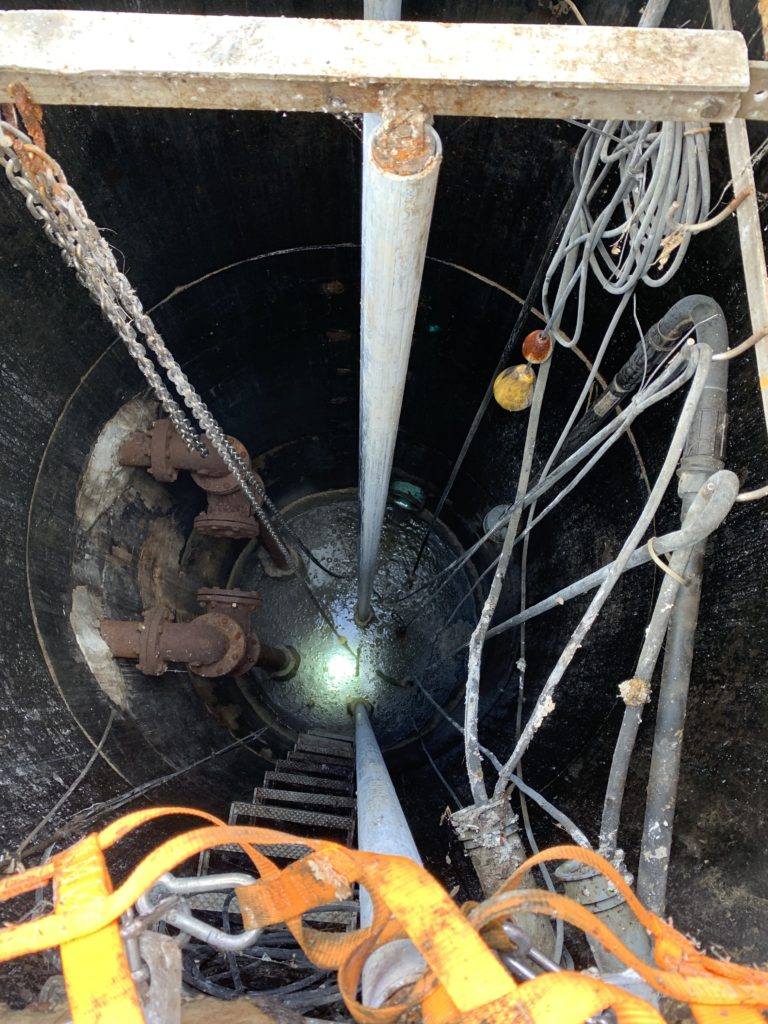
5. Safety – Are your lift station hatches equipped with fall protection? Are your workers using tripods with harnesses for lift station access, or are they relying on deteriorated manhole steps? Review the safety features of your lift stations and make sure your crew has the right equipment to do their job safely. Lift stations are a very hazardous environment, but simple safety features and protocols can make all the difference.
If you are experiencing any of these issues or want more information, we can help.