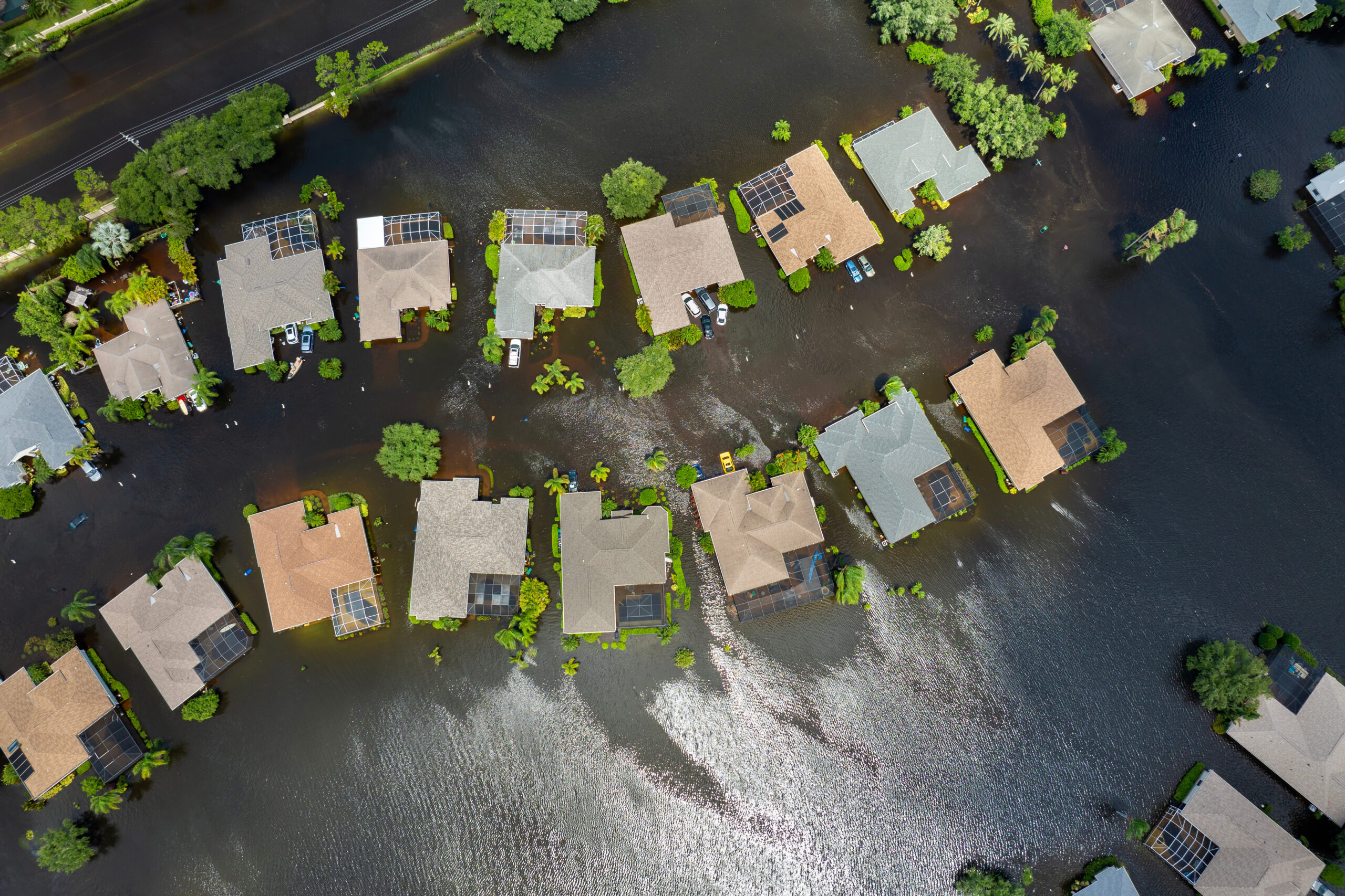
Pete Helder is Director of Survey at WSB, with more than 35 years of experience in the survey and construction industry. Pete has led surveying efforts across municipal, land development, energy and infrastructure projects, with expertise in ALTA/NSPS Land Title surveys, boundary and topographic surveys and right‑of‑way platting. His background includes coordinating survey crews, supporting design for streets and subdivisions and delivering clear, defensible survey information that supports ownership, access and construction decisions. Pete brings a practical, detail‑driven approach to his work and continues to build trusted client relationships through consistent delivery and technical leadership.

Portrait of Pete Helder

What Do You Enjoy Most About Surveying?

What I enjoy most about surveying is the mix of precision, problem-solving, and people. I especially enjoy ALTA/NSPS land title surveys and boundary surveys because they require you to be thorough—researching record documents, weighing evidence in the field, and then turning all of that into a clear deliverable that a title company, lender, owner, and design team can rely on. I like the challenge of resolving questions before they become issues, and I take pride in producing work that is defensible and easy for others to use. As of the past 6 years or so I genuinely enjoy the client development side of survey— building relationships, understanding what a client needs from the survey, and being the person they trust to deliver consistently.

What is the Significance of Surveying?

Surveying is critical because it establishes a reliable source of truth for property and design decisions. For ALTA and boundary work, which means providing certainty around ownership, access, easements, encroachments, and improvements—information that directly supports title, financing, due diligence, and risk management. On the design and construction side, accurate control and topographic information keep teams aligned, reduce rework, and help projects get built where they’re supposed to be. When the survey is right and clearly communicated, it prevents disputes, saves time and money, and gives every stakeholder confidence to move forward.

What Inspired You to Pursue a Career in Surveying?

I was drawn to surveying because it fits how I like to work: hands-on and detail-oriented, with real responsibility behind the finished product. I like that surveying combines field work, record research, and technology, and that good judgment matters as much as good measurements. As I got more exposure to ALTA and boundary surveys, I realized I enjoyed this type of work the most, tracking down the right documents, reconciling record information with field evidence, and producing a map that tells the story clearly. Over time, the client-facing part became just as rewarding; listening to what a client is trying to accomplish and delivering a survey they can trust for decisions and deadlines.

What is a Project You Enjoyed Working On?

One project I especially enjoyed was the Catalina I & II Solar Project—it was our first utility-scale solar project in California. It was exciting because it combined the parts of surveying I like most: careful boundary and records work, efficient field execution over a large site, and strong communication with the broader project team plus I got to travel there weekly while it was freezing cold here in Minnesota. With a project of that scale, there’s a lot riding on getting the boundary, access, and existing conditions documented clearly so the owner, engineers, and contractors can make decisions with confidence. I enjoyed being part of a team that helped set the groundwork for a successful build, and it was rewarding to see our survey work directly support the project as it moved forward.

By Kevin Anderson, Vice President, Structures, WSB

Across the nation, bridge owners face familiar yet evolving pressures: aging structures, demanding corridors, environmental uncertainty, and rising expectations for safe, resilient infrastructure delivered quickly and transparently. Technology is reshaping how agencies respond — not by replacing engineering expertise, but by expanding what teams can anticipate, coordinate, and deliver. Through our work nationwide, three technology‑driven approaches consistently strengthen bridge programs.

1) Modeling Tools That Reduce Construction Risk Before Work Begins

A 3D digital model of a short bridge segment shown in bright colors. The bridge has a blue deck, green abutments, yellow and orange vertical support elements, and light-yellow railings along the sides. The structure appears elevated, with visible substructure components beneath each end.

Bridge work is rarely straightforward. Mountain corridors in Colorado bring steep grades, rockfall zones, and limited access. Urban centers in Georgia compress construction into tight rights‑of‑way surrounded by traffic and multimodal networks. Coastal regions in Florida introduce tidal conditions, storm surge risks, and sensitive environments. Each setting demands its own considerations — and modeling helps reveal them early.

With advanced 3D and 4D tools, WSB teams simulate how a bridge interacts with its surroundings long before construction begins. Digital models capture staging sequences, utility conflicts, structure geometry, rail coordination, hydrology, and traffic operations, giving owners a clear view of potential challenges.

This process naturally engages WSB’s geotechnical, water resources, traffic, environmental, and construction specialists, ensuring decisions reflect the full complexity of the corridor. Early insight leads to greater predictability, fewer field surprises, and solutions aligned with the terrain and community.

2) Data‑Driven Insight for Smarter Planning and Long‑Term Stewardship

Reliable data is transforming how agencies understand their networks. Tools like GIS, LiDAR, digital inspections, and asset management systems support a shift from reactive maintenance to informed, long‑term planning. These technologies help identify structural trends, pinpoint vulnerabilities, and evaluate risk consistently.

Data becomes even more powerful when interpreted through a multidisciplinary lens. Bridges sit at the intersection of mobility, hydrology, geology, utilities, and community development. Drawing on 50+ service areas, WSB teams assess how changing flood patterns might affect piers, how soils influence deterioration, how traffic growth stresses a corridor, or how development reshapes access.

When bridge data aligns with insights from planning, environmental compliance, stormwater modeling, materials testing, and more, agencies can prioritize projects with confidence and invest in safer, more resilient infrastructure.

3) Digital Delivery That Strengthens Coordination and Accelerates Progress

4D model of a highway interchange showing multiple ramps and overpasses, with roadways and structures color‑coded in red, blue, green, teal and purple to distinguish alignments, bridges and surrounding terrain.

Bridge programs today operate under accelerated schedules, heightened public scrutiny, and complex stakeholder expectations. Digital delivery brings clarity and momentum to the process.

Cloud‑based collaboration, automated documentation, digital plan sets, and real‑time design review tools connect project partners and reduce friction. Contractors gain clearer design intent. Designers understand field conditions faster. DOT reviewers access consistent, up‑to‑date information. Construction engineering and inspection teams verify work with greater accuracy.

WSB’s digital workflows span all service areas, creating continuity from concept through construction. Survey updates feed directly into engineering models, environmental changes appear immediately in design reviews, traffic data informs staging, and public engagement materials draw directly from project models. Fewer handoffs and faster decisions keep projects moving.

Technology That Strengthens More Than Bridges

While these innovations improve bridge delivery, their true impact lies in how they connect to the broader transportation system. Bridges influence — and are influenced by — roadway geometry, hydrology, utilities, mobility needs, permitting, construction methods, and long‑term maintenance. Technology enables these relationships to be understood earlier and addressed holistically.

WSB’s multidisciplinary foundation strengthens this work. Our bridge and structures teams collaborate seamlessly with colleagues in transportation planning, geotechnical engineering, water resources, environmental sciences, GIS, construction services, and more to deliver solutions that consider the entire corridor and community.

The result is more than a well‑delivered bridge — it’s a stronger, safer, more resilient system that supports communities now and into the future.

Portrait of Kevin Anderson

Kevin has over 30 years of experience in managing all aspects of transportation projects, including project management, bridge design, construction management, quality management, preliminary and final roadway design, visual quality, right-of-way, utility coordination and design, public information and involvement, and critical path method scheduling. He previously worked 18 years for the Minnesota Department of Transportation in various aspects of design and construction, including ten years of experience in bridge design and inspection. He has been involved in MnDOT’s design-build program on both the owner’s and contractor’s side since its inception in 2001.

612.845.8343

By Keaton Forrest, Field Manager Emergency Management Services, WSB

When an emergency hits, timing, coordination, and communication matter more than ever. Effective response and recovery efforts protect lives, stabilize essential systems, and reduce long-term financial impacts. Strong processes also support residents’ confidence and ensure that the community can rebuild more quickly and more resiliently.

What Is Response and Recovery?

Cities face two critical phases during disasters: immediate action and long-term rebuilding. Response includes lifesaving operations, damage assessments, and rapid activation of emergency systems. Recovery involves restoring infrastructure, securing reimbursement, and guiding the long-term rebuilding needed to make the community stronger.

Benefits for Local Governments

Local governments carry the largest operational burden during emergencies — but the right support can significantly reduce stress, cost, and complexity. Effective response and recovery increase clarity, speed, and financial sustainability.

  • Faster situational awareness: Realtime assessments support quick, accurate decision making.
  • Stronger incident command support: Helps cities maintain order and coordination under pressure.
  • Accurate FEMA documentation: Maximizes reimbursement and reduces financial risk.
  • Efficient resource allocation: Ensure staffing, equipment, and communications operate effectively.
  • Smarter long‑term rebuilding: Supports stronger, more resilient infrastructure for the future.

Benefits for Residents

Residents experience the direct impact of a city’s response and recovery work. Fast, coordinated efforts help reduce fear, protect property, and restore a sense of normalcy as quickly as possible.

  • Faster restoration of utilities and essential services
  • Quicker debris removal and safer mobility
  • More reliable emergency communication and updates
  • Shorter recovery periods for critical public infrastructure
  • A stronger, safer community after reconstruction

How We Support Cities

From the first hours of an emergency to the final stages of rebuilding, our team provides end-to-end support designed for effectiveness and clarity. We help cities manage complexity so staff can focus on serving residents.

  • Rapid damage assessments
  • Debris monitoring and FEMA compliant documentation
  • Emergency Operations Center (EOC) and incident command staffing
  • Long‑term recovery planning and paperwork management
  • Guidance on rebuilding, grant development, and infrastructure improvements

Partner With Us

In the most difficult moments a community can face, having the right experts at your side makes all the difference. Our team provides disaster response and recovery support through rapid assessments, documentation expertise, EOC staffing, debris monitoring, and long-term recovery planning. We understand FEMA’s processes inside and out, ensuring your city captures every eligible dollar while reducing the administrative burden on already stretched staff. Our approach blends technical expertise, field-tested response skills, and a deep commitment to helping cities recover stronger than before.

Cities count on us because we bring clarity to chaotic moments, accelerate recovery timelines, and ensure rebuilding is done with resilience in mind. We stand ready to support your community from the first hours of response through the final stages of reconstruction. Contact us today to learn how our response and recovery experts can support your city when it matters most.

Portrait of Keaton Forrest.

Keaton Forrest is an experienced emergency management leader with a decade of proven service in safety oversight, hazard mitigation, and operational coordination. As an Air Force Wing Corrosion Manager, he served as the owner of a $2 billion corrosion control hazard mitigation program, directing large-scale risk management initiatives and leading teams to strengthen organizational resilience. His leadership included enforcing OSHA, EPA, and Department of Defense standards while managing multimillion-dollar projects that ensured continuity of operations and compliance across multiple work centers.

918.743.6611

By: Shannon McGrath, Director, Asset Management Planning, WSB and Shuvo Islam, Asset Management Lead, WSB

Communities rely on their streets, trails, and corridors every single day and pavement is often the most valuable and most visible asset that cities manage. However, it’s also one of the fastest to deteriorate if not maintained strategically. 

As infrastructure ages and budgets tighten, more municipalities are turning to preventive approaches to pavement management as a foundational step in strengthening their overall asset portfolio. When leaders understand the true condition of their pavements and how those pavements are likely to age over time, they gain the insight needed to prioritize investments, reduce long-term costs ensuring serviceable roads for the community, and plan with confidence. 

Building Smarter, Not Just Smoother 

Traditional approaches often focus on fixing the worst roads first. While intuitive, this reactive approach leads to escalating costs and unpredictable spending. Modern pavement management flips that script by identifying where early, low-cost preventive treatments can extend pavement life and delay the need for costly major reconstruction. 

It’s a simple truth: Protecting good roads before they fail saves communities significant money down the line.

WSB supports this shift by combining engineering expertise with modern tools to deliver clear, defensible insight into pavement condition and need. 

A More Advanced, Accurate Approach 

Advances in technology now allow communities to assess pavement networks with greater accuracy and consistency. WSB incorporates: 

  • Automated condition data collection to reduce subjectivity 
  • AI supported distress identification for improved accuracy and efficiency 
  • Customized deterioration modeling based on local climate, traffic, and materials 
  • GIS integrated inventory management to better inform capital planning and communication to strengthen capital planning and coordination 
  • Integration into enterprise asset management systems (EAMS) to coordinate with other asset needs, such as underground utilities 

While tools and automation are accelerating the work, engineering oversight remains essential. Our team validates results, interprets the data, develops performance models, and collaborates with clients to translate findings into practical treatment strategies. 

Driving Better Decisions and Better Outcomes 

With a strong pavement management program, communities can: 

  • Improve overall network condition 
  • Prioritize projects with confidence 
  • Stretch limited dollars further 
  • Reduce emergency repairs and service disruptions 
  • Coordinate street work with underground utility needs 
  • Build more predictable, transparent capital plans 

For municipal leaders, these benefits directly support safer streets, better experiences for residents, and more resilient infrastructure. 

Strengthening Your Community’s Foundation 

Pavement is more than a surface; it’s the backbone of mobility, commerce, and daily life. A thoughtful, data driven pavement management strategy gives communities a powerful tool to protect that backbone and invest wisely in the future. 

If your city is looking to modernize its approach, improve performance, or align limited resources with long-term goals, our team at WSB is here to help. 

Portrait of Shannon McGrath

Shannon has spent 17 years in GIS, data analysis, asset management, and planning. She has been involved in advancing asset management at local, state, and national levels by serving on asset management committees, advisory panels, and project management teams. While working at MnDOT, Shannon directed agency-wide asset management planning including projects, research, policy, innovation, strategic planning, and implementation in collaboration with internal and external stakeholders. She is experienced in conducting risk assessments, life cycle planning strategies, developing performance measures and targets, cross-asset trade-off decision making, determining asset management system needs, investment scenario planning, climate risk modeling, and other planning efforts.

651.492.9291
Portrait of Shuvo Islam.

Pavement Management Expert with a Ph.D. in Civil Engineering (pavement engineering focus), bringing 5+ years of experience implementing and optimizing pavement management systems for transportation agencies. Specialized in condition data governance, PCI/ASTM compliance reviews, predictive model configuration and calibration, budget & treatment scenario modeling, and workflow optimization across preservation and rehabilitation programs. Experienced in aligning pavement management goals with municipal constraints and communicating tradeoffs and recommendations to leadership.

919.744.8240

By Amber Adams, Grants & Funding Program Manager, WSB

If you’re leading a local or tribal government right now, you’re likely managing the same mix we hear across the country: aging systems, rising costs, limited staff capacity, and community expectations that don’t slow down. The encouraging news is that 2026 still offers meaningful federal support for infrastructure but the communities that benefit most aren’t the ones that start when a Notice of Funding Opportunity (NOFO) drops. They’re the ones who have the essentials in place before the clock starts. 

Water Infrastructure Funding Remains a “Workhorse” in 2026 

State Revolving Funds (SRFs) continue to be one of the strongest channels for water, wastewater, and stormwater projects, with states receiving annual allotments and distributing funds on their own schedules. EPA has also highlighted recent SRF funding announcements that include allocations for states, Tribes, and territories, reinforcing the continued scale and relevance of these funding streams. 

SRF-supported priorities commonly include: 

  • PFAS and emerging contaminant mitigation 
  • Stormwater and sewer overflow improvements 
  • Lead service line replacement
  • Distribution and collection system modernization 

EPA’s $4B Annual Environmental Funding Continues Strong Cycles 

EPA remains one of the largest and most consistent federal funders, awarding more than $4 billion each year in grants and assistance agreements to state and local governments, Tribes, universities, nonprofits, and other eligible entities. 

Many EPA opportunities recur over time, and preparedness is often the best differentiator especially for projects tied to compliance, resilience, stormwater, and environmental health outcomes. 

What This Means for Municipalities and Tribal Nations 

Taken together, these funding channels make one thing clear: 2026 isn’t just an application year; it’s a readiness year. Communities that prepare now are best positioned to move quickly as state programs, EPA regions, and recurring federal opportunities open funding windows. 

What We’re Seeing in Successful Communities 

Across the country, we’ve watched communities turn preparation into real results. Some can move quickly when funding windows open because they already have scopes, cost ranges, and key documentation in hand. Others reduce internal friction by using a simple one-page project summary to keep leadership aligned making it easier to respond confidently when opportunities surface. 

In every case, the common thread isn’t community size or geography, it’s readiness

5 Steady Steps Communities Can Take This Spring 

These are not high-pressure tasks; just steady moves that consistently help communities compete and deliver successfully. 

  1. Focus on your most fundable priorities (start with two): Instead of trying to advance everything at once, identify the two projects with the clearest community benefit and strongest alignment with funding priorities public health protection, regulatory compliance, resilience, or service reliability. These themes match closely with how SRF and EPA programs evaluate projects. 
  2. Create a one-page project snapshot for each priority: Include the problem, proposed solution, location, rough cost range, schedule, benefits, and what’s already done. This helps with leadership alignment and speeds up applications. 
  3. Connect early with the right funding gatekeeper: For SRF, processes vary and are administered by states. For certain tribal set-aside programs, coordination may occur through EPA regions (and often with IHS involvement for delivery). 
  4. Do a quick readiness check before the window opens: Ask yourself: Do we have a clear scope? Current cost estimates? Environmental or permitting needs identified? A realistic schedule? SRF and EPA-funded projects often slow down when readiness gaps emerge late, catching them now keeps your team confident and proactive. 
  5. Sketch a practical funding stack: Not every project will be a perfect match for a single grant. Many successful projects braid SRF loans with local funds and other state/federal sources. Even a rough outline helps councils weigh options and positions you to move faster when opportunities open. 

A Final Encouraging Thought 

Communities that make steady, manageable steps now rather than reacting once a NOFO appears tend to secure more funding, reduce risk, and deliver projects more smoothly. With SRF and EPA funding mechanisms remaining major infrastructure levers, readiness is still one of the most reliable advantages a municipality or tribal nation can build. 

And if at any point you want a neutral perspective on where your projects stand or what documentation would strengthen your next submission, WSB is always here as a steady partner invested in your community’s long-term success. 

Amber Adams Portrait

Amber is an accomplished business executive specialized in driving funding initiatives that lead to business development. She is exceptionally skilled in cultivating strong working relationships, strategic planning, research, leading cross-functional teams, grant writing and administration, project management, and operational efficiency. She has overseen federally funded grants, which led to award-winning, model programs, economic development, jobs, and sustainability.

405.492.8069

By Allison Whitsitt, Director, Emergency Management, WSB

Being ready before disaster strikes is essential for protecting both residents and city operations. Preparedness and mitigation offer communities the opportunity to reduce risk, increase safety, and lower long‑term costs. These proactive efforts lay the foundation for confidence, resilience, and stability across all departments.

What Is Preparedness & Mitigation?

Before a disaster occurs, cities must understand their risks and rehearse their response. Preparedness focuses on planning, training, and coordination so staff know exactly how to act during an emergency. Mitigation strengthens the physical and operational systems that keep a city functioning, reducing future impacts from storms, infrastructure failures, or other hazards.

Benefits for Local Governments

Cities that invest in preparedness and mitigation plans experience fewer disruptions and are better equipped to protect budgets, operations, and community assets. These benefits extend across public works, administration, emergency operations, and long‑term capital planning.

  • Reduces damage to public infrastructure: Reinforces vulnerable systems and reduces costly repairs.
  • Strengthens emergency coordination: Ensures all departments understand their roles and communication pathways.
  • Protects municipal budgets: Lowers unplanned recovery expenses and avoids reactive spending.
  • Improves access to federal funding: FEMA‑aligned plans unlock grants that fund resilience projects.
  • Enhances continuity of operations: Keeps essential city services running even when conditions deteriorate.

Benefits for Residents

When cities prepare effectively, residents feel it — not just during a disaster, but every day. Strong preparedness and mitigation plans create safer neighborhoods, reduce disruptions, and support community trust.

  • Safer homes and neighborhoods during severe weather
  • Fewer service outages across power, water, and road systems
  • More reliable information when emergencies occur
  • Stronger faith in local leadership and emergency processes

How We Support Cities

Our team guides cities through a comprehensive, data‑driven approach to preparedness and mitigation planning. By combining technology, expertise, and municipal understanding, we help communities plan smarter and act with confidence.

  • Risk and vulnerability assessments
  • FEMA‑compliant Hazard Mitigation Plans
  • Preparedness drills and training exercises
  • GIS- and AI‑powered mapping and analysis
  • Infrastructure resilience recommendations tailored to local needs

Partner With Us

Building a resilient community requires more than plans on paper — it requires a partner who understands the complexities of municipal operations, the pressures city staff face, and the funding and regulatory landscape that shapes emergency planning. Our team brings decades of combined experience in FEMA‑aligned planning, hazard mitigation, GIS‑based risk analysis, military leadership, and hands‑on municipal support. We’ve helped communities of all sizes strengthen their infrastructure, secure critical federal funding, and build preparedness programs that truly work in real-world conditions.

By working with us, your city gains a dedicated partner invested in reducing risk, protecting public assets, and ensuring your residents are safer and better informed when emergencies occur. Whether you need help assessing vulnerabilities, securing grants, updating emergency plans, or training staff, we’re here to support every step of your preparedness and mitigation journey. Reach out to our Emergency Management team to start enhancing your city’s resilience today.

Portrait of Allison Whitsitt in a black sweater and a silver necklace with a turquoise pendant, seated indoors with green plants in the background.

Allison served as the Northeast Regional Coordinator for the Oklahoma Department of Emergency Management and Homeland Security. Allison is the Director of Emergency Management and oversees projects including Hazard Mitigation Plan updates, new and existing Emergency Operations Plans, and application/submission of state and federal grants along with various other work.

918.728.5617

By: Chhavi Dhingra, Public Engagement Senior Manager, WSB

Part 2 of our series, Digital Accessibility in Practice: Moving Beyond Compliance, explores how accessibility works best when addressed in an upstream manner.

Document remediation using built-in accessibility checkers or more advanced tools such as CommonLook plays a key role in identifying issues and supporting quality control, particularly for legacy content. However, experience and broader trends indicate that accessibility is most effective when it is addressed from the outset. Accessibility should be viewed as a fundamental requirement in the creation and design process of digital content.

When accessibility considerations are integrated directly into native files the need for downstream remediation is significantly reduced. Native files include Word documents, PowerPoint presentations, and Excel spreadsheets.

Moving beyond compliance means adopting consistent and recommended approaches at the point of content creation, including:

  • Adding proper document titles and author information to its properties
  • Using proper heading styles to establish a clear and logical structure
  • Writing alternative text that conveys purpose and context, not just appearance
  • Using descriptive link text instead of generic phrases or long/complex URLs (Uniform Resource Locators)
  • Designing tables with simple layouts and clearly defined headers
  • Introducing acronyms by spelling them out at least once
  • Ensure meaning is not conveyed by color alone and is supported by text or symbols
  • Maintaining sufficient contrast between text and background colors
  • Confirming that content can be navigated using a keyboard
  • Using plain, concise language wherever possible
  • Using the ‘Check for Accessibility’ feature and manually checking reading order of documents

These practices by no means restrict creativity. In fact, they improve clarity, reduce ambiguity, and result in content that works more consistently across formats and platforms.

From Compliance to Capability

Digital accessibility becomes sustainable when it is treated as part of everyday work rather than a specialized or corrective task. This shift requires awareness, shared responsibility, and a willingness to revisit long-standing practices. Importantly, digital accessibility is not about achieving perfection; it is about intention, consistency, and continuous improvement.

Organizations that invest in accessibility as a practice often realize broader benefits, including clearer communication, stronger documentation, improved usability, and more consistent user experiences. Compliance may be one outcome, but the greater value lies in creating digital content that more people can reliably access and use.

At WSB, we are continuing to strengthen our accessibility practices by collaborating with partners and clients to integrate accessibility. Whether into document creation, remediation, or web content. As this continues to evolve, we look forward to sharing additional insights and lessons learned from applying accessibility in practice.


Follow along our new series, Digital Accessibility in Practice: Moving Beyond Compliance as we explore practical steps to make digital spaces truly inclusive. Part 1 is available here.

Portrait of Chhavi Dhingra

Chhavi Dhingra is the Public Engagement Senior Manager at WSB. With nearly two decades of experience as transportation engineer and public engagement professional. She leads her team in developing sustainable policies, practices, and communication strategies. With a focus on addressing accessibility needs of disadvantaged communities, Dhingra has lead engagement with multistakeholder partnerships and worldwide transportation projects.

917.328.3588

Part 1 of the Digital Accessibility in Practice: Moving Beyond Compliance series features everyday practice to bridge the gap between compliance and accessibility.

Digital accessibility refers to the practice of designing digital content that can be accessed and used by people with a wide range of abilities. Digital content includes documents, websites, tools, and media. Those who rely on assistive technologies such as screen readers, keyboard navigation, captions, or voice recognition software need this accessibility. At its core, accessibility ensures that information is perceivable, understandable, and usable by as many people as possible.

The more one works with digital accessibility, it becomes clear that it is a thoughtful, nuanced, and continually evolving discipline. Shaping how information is created, structured, and shared. Embedding accessibility in how we communicate through digital media requires shifting focus. From meeting minimum standards to considering accessibility from the very beginning.

While tools such as Word, PowerPoint, Excel, and PDF software include robust accessibility features, they often go unutilized. Especially because those features are largely and rarely part of standard content-creation habits and are therefore easy to overlook.

Designing for Sighted Users Is Not Designing for Everyone

Several commonly used design choices often prioritize users who can visually interpret content and navigate with a mouse. Design choices include icons or emojis, color-coding information, splitting or merging tables. Moreover, enhanced layouts with complex graphics without a description in the body of text. What is less frequently considered is how this same content is experienced by someone using a screen reader, navigating exclusively by keyboard, or accessing content with low vision, color blindness, cognitive disabilities, or limited motor control.

Content that appears polished and visually engaging can still present significant challenges depending on how it is structured and navigated. Design choices that rely heavily on visual cues or mouse-based interaction may limit access for users who rely on assistive technologies. Common examples include:

• Images, charts, or icons without meaningful alternative (alt) text

• Headings that are visually styled but lack a logical structural hierarchy

• Tables that use merged or split cells, disrupting reading order

• Information conveyed through color alone, without supporting text or symbols

• Forms or interactive elements that cannot be completed using a keyboard alone

For individuals using screen readers, keyboard navigation, or other assistive tools, these factors directly influence whether content is understandable and usable.

Common structural and interaction barriers 

Beyond individual design elements, digital accessibility challenges also arise from how content is written, organized, presented and programmed. Frequently observed issues across digital platforms include:

• Dense language, long sentences, and unexplained technical or institutional jargon

• Poor color contrast affecting users with low vision or color blindness

• Inconsistent or illogical use of heading levels, disrupting navigation

• Improperly tagged graphics or diagrams created in design tools

• Lack of visible focus indicators to show where a user is on a page

• Tasks or time-based interactions that do not allow sufficient flexibility or adjustment

At WSB, our work to address accessibility for digital communications is already underway. We are supporting our partners and clients through document accessibility reviews, remediation, and guidance on building accessibility into everyday document and web content creation.


Follow along our new series, Digital Accessibility in Practice: Moving Beyond Compliance as we explore practical steps to make digital spaces truly inclusive. Part 2 of this series will focus on practical ways organizations can address these challenges by embedding accessibility into everyday content creation and workflows.

Portrait of Chhavi Dhingra

Chhavi Dhingra serves as Public Engagement Senior Manager at WSB, where Dhingra leads strategic initiatives that drive innovation and operational excellence across public engagement. With extensive experience, she excels in developing sustainable policies, practices, and communication strategies, and has a proven track record in leading stakeholder management for transportation and transit projects. Chhavi has contributed to numerous road transportation planning projects worldwide, focusing on engagement, multi-stakeholder partnerships, and strategic communications to address the mobility and accessibility needs of disadvantaged communities.

917.328.3588

By Shelly Woodall, Sr Right of Way Specialist, WSB

City infrastructure projects, whether building new roads, expanding utilities, or creating public spaces, are complex undertakings. They require more than engineering and construction expertise; they demand strategic land management and strong community relationships. This is where Right of Way (ROW) agents step in as essential partners for municipalities.

ROW agents ensure that projects move forward smoothly, on time, and within budget by managing the critical processes that connect city plans to private property realities. Below, we explore the comprehensive services ROW agents provide and why they are indispensable for successful city projects.


Relationship Development with Landowners

Every project begins with trust. ROW agents build and maintain positive relationships with property owners, fostering open communication and addressing concerns early. This proactive approach minimizes conflict and sets the stage for cooperative solutions.

Permitting

Permitting can be a maze of local, state, and federal requirements. ROW agents navigate this complexity, securing timely approvals and ensuring compliance so projects stay on schedule.

Land Acquisition

Acquiring property rights is often the linchpin of a project. ROW agents manage the entire acquisition process, from initial outreach to closing, ensuring fair transactions and adherence to all regulations.

Title Work

A clear title is non-negotiable. ROW agents coordinate title searches, resolve encumbrances, and prepare documentation to protect the city’s investment and avoid legal complications.

Appraisals

Fair compensation starts with accurate valuation. ROW agents work with certified appraisers to deliver defensible property valuations that meet legal and ethical standards.

Land Surveys

Precision matters. ROW agents coordinate land surveys to establish boundaries and identify potential issues before construction begins, preventing costly surprises later.

Negotiations

Negotiation is both an art and a science. ROW agents bring experience and tact to secure agreements that balance project needs with property owner rights, reducing delays and disputes.

Eminent Domain

When voluntary acquisition isn’t possible, ROW agents guide municipalities through the eminent domain process, ensuring compliance with the Uniform Act and state laws while maintaining transparency and fairness.

Relocation Assistance

Displacement can be disruptive. ROW agents provide relocation assistance to residents and businesses, offering guidance and resources to ease transitions and minimize hardship.


Partner with WSB for Comprehensive ROW Solutions

At WSB, we understand that right of way services are more than transactions, they’re about building trust and delivering results. Our team of experienced ROW agents offers all these services, backed by deep regulatory knowledge and a commitment to collaboration. Whether your city is planning a roadway expansion, utility project, or trail development, WSB is here to help you navigate every step of the process with confidence.

Ready to move your project forward? Connect with WSB today and discover how our ROW expertise can turn challenges into opportunities for your community.

By: Jared Langley, Remote Sensing Manager, WSB

The infrastructure industry is undergoing a quiet but powerful transformation. As technology advances and expectations rise, firms are asked to deliver more and with greater precision. Remote sensing has emerged as a key enabler of this shift, offering a new lens through which we can view, understand, and shape the built environment.  

Remote sensing refers to the collection of data about the Earth’s surface from a distance, using technologies such as LiDAR (Light Detection and Ranging), photogrammetry, and UAVs. These tools allow us to capture high-resolution, geospatially accurate information quickly and safely, often over vast or hard-to-reach areas. But the true value lies not just in the data itself but in how that data is interpreted, integrated, and applied across the lifecycle of a project. 

Across all phases, remote sensing is a powerful enabler of smarter, faster, and safer project delivery. It provides timely, high-resolution data that supports early decision-making, enhances design accuracy, streamlines construction oversight, and strengthens long-term asset management. By integrating this technology into every stage of the project lifecycle, teams gain a clearer understanding of site conditions and can respond with greater agility and confidence.  

Choosing to utilize remote sensing is a strategic decision, and selecting a provider backed by full-service engineering expertise unlocks even greater value. When remote sensing is embedded within a multidisciplinary firm, data collection seamlessly aligns with planning, design, and construction workflows. The benefit is a unified team that understands the full project lifecycle and can translate geospatial intelligence into smarter infrastructure solutions from day one. 

1. Accelerated Decision-Making from Day One 

In the planning phase, remote sensing accelerates decision-making by providing rapid, large-area aerial surveys and 3D terrain models. These datasets support feasibility studies, environmental impact assessments, and early alignment planning, helping teams evaluate multiple corridors or sites before committing field crews. This early insight reduces risk, saves time, and ensures that projects begin with a strong foundation of information. 

2. Enhanced Design Accuracy and Real-World Context 

As projects move into design, remote sensing continues to add value. High-density point clouds and digital twins offer engineers a detailed, real-world context for their work. The result is more accurate designs, fewer surprises in the field, and a smoother path from concept to construction. 

3. Transparent Construction Oversight and Documentation 

Remote sensing enhances surveying, too. Mobile and aerial LiDAR, combined with UAV-based imagery, allow survey teams to collect data more efficiently and with greater detail. During construction, remote sensing introduces a new level of objectivity and transparency. UAV flights generate dated, auditable orthomosaics and 3D models that document site conditions over time. These records support pay applications, earthwork validation, and compliance checks, reducing disputes and building trust among stakeholders.  

4. Smarter Project Delivery 

Digital construction management is another area where remote sensing plays a critical role. By feeding real-world conditions into digital platforms, we enable 4D scheduling, model-to-field alignment, and continuous validation. This creates a closed-loop system where design, construction, and reality are always in sync, ensuring that what’s built matches what was planned. 

The industry is evolving, and so are the expectations placed on engineering and consulting firms. Clients want faster turnaround times, scalable solutions, and GIS-ready deliverables. Remote sensing helps meet these demands by accelerating data collection, minimizing field risk, and enabling customized analysis. Firms with internal remote sensing capabilities are better positioned to respond to these needs and anticipate the requirements of future contracts.  


How WSB Can Help

At WSB, our remote sensing team works hand-in-hand with planners, engineers, surveyors, and construction managers. This integrated approach ensures that high-resolution data is not only collected but transformed into actionable insights. It’s a model that enhances accuracy, streamlines workflows, and delivers better outcomes for clients across all markets. 

Remote sensing is more than a tool, it’s a catalyst for smarter, more efficient infrastructure delivery. And when paired with the depth and breadth of a full-service firm, it becomes a powerful differentiator. As the industry continues to evolve, WSB remains committed to leading with innovation, insight, and integrated expertise. 

Portrait of Jared Langley

Jared Langley serves as Remote Sensing Manager in WSB’s Survey department, based in Fargo, ND. With expertise in aerial mapping and geospatial technologies, Jared leads initiatives that integrate advanced remote sensing solutions into surveying workflows. He oversees specialized programs, including UAS operations, and collaborates on projects involving end-user licensing and AI-driven mapping tools. His leadership ensures innovative approaches to data acquisition and analysis for infrastructure and environmental projects

701.302.0320
WSB Staff working in the lobby of the WSB headquarters.

Discover Our Difference

We partner with our clients and communities to build what’s next in infrastructure – the places, spaces, and systems that support our lives.