TH 169

MnDOT’s Corridors of Commerce program: What’s New in 2022

By Mary Gute, Sr. Transportation Planner, WSB

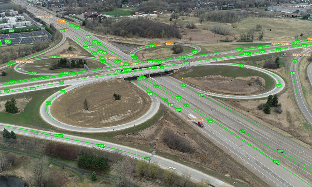
A healthy economy is dependent upon an efficient transportation system. To foster economic and commercial growth across our state, the Minnesota Department of Transportation’s (MnDOT) Corridors of Commerce program is now open for applications. The program helps communities make highway capacity improvements where there are bottlenecks, as well as improve the movement of freight and other barriers to commerce. 

The Project Recommendation Process and What’s New in 2022

MnDOT will determine program recipients using an online recommendation process. 2022 has some additional requirements and new guidelines as well. Here are some important details regarding what is new for submitting a proposal for consideration. 

Who can submit a proposal? As of this year, only an individual acting as an official representative of one of the qualifying organizations below may submit a project for consideration. 

  • An area transportation partnership
  • Any city, county, or township in Minnesota
  • Any tribal government in Minnesota
  • Any corridor coalition which is formally organized as a not-for-profit organization.
  • Any metropolitan planning organization
  • Any regional development organization

Additionally, each organization is limited to submitting one project recommendation per cycle. 

Provide cost estimates and funding details. Make sure your project has a leg up by laying out funding resources and cost estimates. New requirements for this year include a detailed project description that corresponds to identified cost estimates, as well as a cost estimate reviewed and agreed to by a State of Minnesota licensed engineer. Any other committed funding sources must also be identified along with the name and contact for those sources.  

Make sure your project scores well upon review. Your project was submitted online and met all the eligibility and project recommendation requirements. How to ensure your project stands out? State law requires that projects be scored based on the following criteria, so make sure to highlight:

  • Return on investment with a focus on travel time reduction and/or an anticipated reduction crashes.
  • Economic competitiveness that is measurable in its impact on job growth and direct and indirect economic development.
  • Freight efficiency measurements including time travel savings, average daily heavy commercial travel, and travel reliability. 
  • Safety criteria, which impacts multiple scoring areas, focused on 5-year averages of crashes, injuries, and fatalities. 
  • Regional connections including to area commercial trade hubs, highway systems, and to other transportation modes like ship, air, and rail. 
  • Policy objectives with an emphasis on transparent decision making, system stewardship, and healthy communities. 
  • Community consensus, providing resolutions and/or letters of support from municipalities and counties touched by the project, local planning agencies, and a chamber of commerce. 
  • Regional balance to ensure that projects across the state and various regions can tap into opportunities to foster economic development, growth, and commerce through the Corridors of Commerce program. 

By looking ahead and factoring the scoring process into your project planning and ensuring that your project meets all the requirements, you can increase the likelihood of your project being selected. Projects with the highest scores will receive funding first, with exceptions for regional balance which may result in some lower scoring projects taking precedence. 

Project Eligibility

The first step is to explore project eligibility requirements and ensure your project can rise to the top of the selection process. From MnDOT, here is a review of the basic requirements needed for your project.

  1. The project must be classified as either develop additional system capacity or improve freight movement.
  2. Projects must be in line with and adhere to MnDOT’s Statewide Multimodal Transportation Plan.
  3. Projects must be able to begin construction within 4 years of being awarded funding, but the actual construction start may be delayed beyond 4 years to avoid significant impacts to the traveling public.
  4. Projects must be on the Interregional Corridor Network in Greater Minnesota or a state highway in the eight-county MnDOT Metropolitan District.
  5. The amount of corridors of commerce funding needed to construct the project cannot exceed the amount of funding available. 
  6. A project that is listed in MnDOT’s State Transportation Improvement Program (STIP) is not eligible for funding, unless the project was listed in the STIP because it previously received funding.

Are you considering applying for the Corridors of Commerce funding? Applications are due November 30. 

Corridors of Commerce is a highly competitive program and bringing in outside experts who are well-versed in applying for and receiving funding can help ensure that you are set up for success.


Mary has 20 years of progressively complex transportation planning and project management experience, gained from working on a variety of transportation projects for modes including roads/bridge, transit, and trails. Several these projects have included environmental documentation considerations – either pre-NEPA, or through NEPA and/or MEPA processes.

[email protected] | 612.741.7055

3D design

Our Approach to Digital Delivery

Introducing Digital Plus

The future of project delivery

Beyond paperless

For many years, the AEC industry has been embracing advancements in the way we deliver projects.  Paperless plans were the first step in this process. Fast forwarding to today, paperless plans have evolved one step further. People often refer to any digital plan set as paperless, but at WSB, we take our designs one step beyond paperless by creating 100% models. 100% models mean the entire project is created and designed in 3D.

100% models house data and design information from the entire project lifecycle, leaving owners and contractors with an accurate, detailed, data-based model to support asset management needs well into the future.

The development of DigitalPlus

WSB is committed to leading our industry in the use of cutting-edge tools to work smarter.  As a firm, we’ve been at the leading edge of digital delivery efforts for many years.  Our approach is unique and one that has been internationally recognized as a best practice in digital project delivery.  To help tell this story, we created DigitalPlus. 

DigitalPlus is the future of digital delivery. Through a combination of cutting-edge tools, expertise and a commitment to innovation, we are shaping the way our industry delivers projects. We believe in advanced project delivery, and we know how to apply the right technology and expertise to support our infrastructure needs. Through DigitalPlus, we are setting new standards, developing best practices and changing our industry’s approach to multidimensional digital design.

Why DigitalPlus

As engineers, we are motivated by the opportunities to design infrastructure projects that support our communities. The infrastructure around us has a significant impact on our daily lives. From drafting plan sets to public meetings, we live in the details and embrace the full process.  We also embrace the advancements in our industry and how we can leverage technology to deliver better projects for our clients.


The benefits

  • Improve Quality
  • Sustainability
  • Enhanced Scheduling
  • Better Managed Risk
  • Relationship Management (Contractors | Owners)
  • Improve Cost
  • Increase Collaboration and Communication

What is DigitalPlus

A combination of expertise and cutting-edge tools.

Data Collection

Data is the foundation of any good project. We use several traditional data collection methods to gather data points that help paint a picture of the world around us. Good data is vital to the DigitalPlus process.

3D Design

Designing in 3D allows us to develop the project while providing a complete and accurate picture of the final product, significantly improving project outcomes.

4D / 5D

4D/5D modeling improves accuracy and efficiency by adding time and cost functions into design. The true power lies in the way a model can be used during preliminary design, final design and throughout construction.

Asset Management

Asset Management is the collection of an agency’s infrastructure assets and includes a plan for managing assets over the infrastructure’s lifespan. Through digital twins, assets can be managed virtually and accurately.

Utility Coordination

Digital delivery aids utility coordination by translating utility information into a 3D environment that can be compared with the design to identity and mitigate conflicts.

Visualization

Real-time 3D visualization has completely transformed site-specific review and public engagement efforts. Visualizations allow for active participation regardless of project scope and size.

Traffic Operations

Through simulation technology and trip-origin destination data, roadway designs are now guided by real-time and historical mobility movement data.

Integrated Project Delivery

A process, rather than a project that all starts with an idea. Through a combination of expertise and cutting-edge tools, land developers and owners identify opportunities and challenges before a project begins.

Machine Control Modeling

Using 3D models and GPS data, machine control modeling allows earthwork machinery to be accurately positioned. Design surfaces, grades and alignments are directly imported into construction equipment, resulting in increased accuracy and timelines.


To learn more, visit: www.wsbdigitalplus.com

Infrastructure resiliency

Green Infrastructure & Improving Project Resiliency

By Jake Newhall, Project Manager and Ray Theiler, Project Engineer, WSB

Extreme rainfall events are seemingly occurring more frequently than in the past. The frequency at which Americans are experiencing severe weather events due to climate change means building resiliency into infrastructure is more critical than ever. The influx of funding made available from the $1.2 trillion infrastructure package is giving many communities unprecedented opportunities to make significant infrastructure improvements, and it’s important for community leaders to explore how resiliency in planning and building can bring both short and long-term benefits.

One solution to build resiliency in planning is through green infrastructure, which helps absorb water and emulate natural water cycles. Green infrastructure can significantly reduce environmental impacts and pollution and can also be far more resilient and economical for communities.

Exploring Green Infrastructure & Solutions to Improve Resiliency

As communities explore resiliency and green infrastructure, they must first consider their specific needs and impacts. From there, they can determine projects that most greatly benefit from investment in green infrastructure. Resiliency comes in many forms and can be built into a wide variety of community projects.

Is your community prone to flooding? Stormwater-related infrastructure including stormwater re-use for irrigation, allowing park space to flood during large events, incorporating overland overflows into drainage systems, tree planting to improve canopy, and slope stabilization can all be environmentally friendly and help reduce impacts from extreme weather events. Does your area often face drought or water shortage? Reuse of stormwater for irrigation also reduces the burden on potable water and depleted aquifers. There are also private entities and smaller public projects that can build in conservation practices to reduce impact like rooftop gardens or native landscaping. Aging service lines can be replaced to improve resiliency and drinking water quality.

Transit and roadway improvement can also include green infrastructure that strengthens resiliency and reduces environmental impact. Some alternatives include tree trenches, native plantings, vegetated depressed medians, incorporating linear best management practices, and evaluating retrofits to the existing storm sewer system as part of transportation infrastructure planning will improve sustainability.  

Think Ahead & Think Big Picture

With the influx of additional federal dollars available for infrastructure projects, communities must think ahead and think big. Whether it’s getting on the project priority list, putting forward a feasibility plan, or including green infrastructure early in a transportation project planning process, thorough, thoughtful preparation is key and can help ensure your project secures funding.

It’s also vital for communities to go back and look at projects that may have been previously out of budget or may have not quite made the cut due to other projects competing for limited grant dollars. The federal infrastructure law provides another meaningful opportunity to secure funding for projects that may have previously been out of reach.

Plus, if a community plans a project with big picture thinking – like a transit project that includes all the green infrastructure planning up front, for example – it can improve the odds of scoring higher in the grant application process, as well as provide long-term social benefits and economic savings. It’s often easier to build all at once, rather than do piecemeal fixes later.

How WSB Can Help

If your community is exploring how it can tap into opportunities to improve infrastructure resiliency and invest in green infrastructure, WSB can help.

Our firm can inventory lead water service lines with our GIS services. Our team can help review capital projects, risk areas, or identify how to score higher on project grant applications and better utilize funding. We design, plan, and build green infrastructure projects that help communities better manage and protect their water and other natural resources. WSB can also help communities navigate the project priority list and intended use plan process.

Every project is different, and every community is different. But as we face a changing climate and more severe weather events, green infrastructure and more resilient infrastructure is critical to communities, residents, and our environment.

Jake has more than 15 years of engineering experience designing and managing many types of water resources projects, including modeling, planning, design, maintenance programs, and construction. Jake has worked with various municipalities, counties and state agencies to solve challenging water quality and water quantity problems.

[email protected] | 763.231.4861

Ray is a Project Engineer specializing in project planning, feasibility studies, computer modeling, preliminary and final design, bidding, construction management, grant writing, wellhead protection planning, risk assessments, emergency response planning, community engagement, and state water permitting.

r[email protected] | 612.360.3163

Writing an RFP to Maximize your Project’s Potential

By Lori Johnson, Sr Professional Community Planner and Laura Melcher, Sr Business Development Coordinator, WSB

Government leaders, whether at the city, county, or state level, face numerous engineering and infrastructure project needs that often require outside consultants and experts. When putting together a request for proposal (RFP), communities have an opportunity to better communicate those needs and requirements to improve the responses they receive. A well-written and informative RFP allows you to find the right outside partner to meet your needs. 

Below are some ways government staff can build a concise, well-organized, and effective RFP to ensure hiring the right consultant to reach your goals.

Communities can get more out of their consultants and establish better relationships by writing an RFP that lays out clear expectations and goals. A higher level of detail in your RFP will increase the responding firms ability to meet and exceed your RFPs expectations. 

Here are a few things to consider when composing your RFP:

  1. Be specific and customize your RFP. It’s important to clearly outline specific sections that you would like answered so that every detail is accounted for, ensuring firms can provide meaningful details on how to accomplish your goals.  
  2. Be detailed about your specific project. The more details you can provide upfront the better. This will allow consultants to be more specific in their writing, better showcase their applicable skills, and maximize potential without guessing at what should be included or how their services will meet your requirements. 
  3. Highlight your top priorities and concerns. By being open about what is most important, what concerns exist, and what stakeholders will be involved in a project, consultants are able to better understand exactly who they need to bring in from their team and how they can provide proper support and expertise. 
  4. Allow time for questions and communication with potential partners. Creating set times for potential firms to connect and ask questions, like a virtual Zoom session, is helpful to ensure no details are missed and applicants have a clear picture of your expectations. Having these meetings at least two weeks prior to the submission date is helpful, as consultants work on specific timelines to ensure you get a quality proposal. 
  5. Ensure that your RFP defines specific submission requirements and clear deadlines. There should be at least one month between the release of an RFP to its application deadline, as this allows firms to put meaningful time and effort into a proposal. If you have a good idea about how the proposal should be organized, page number requirements can be used to ensure the consultant is concise and follows directions. It is also helpful to be clear if the submission should be electronic or printed and mailed. The address or contact email should be given to allow the consultant to deliver it on time and to the correct location/person.
  6. Provide a clear budget when possible and comprehensive scoring criteria. Every project has a budget and budget limitations. Communicating that information will help a firm build a proposal that fits within your budget. Make sure you accurately communicate how you weigh different sections of a proposal. If the budget is weighted heavily, state that clearly in your RFP. 
  7. If a firm isn’t awarded the contract, offer honest insight and feedback. After interviewing firms or evaluating the proposals, you must choose the right one for your project. For those who weren’t chosen, provide honest feedback. This ensures that consultants gain a better understanding of what they can improve for next time. A good consultant will take constructive criticism and use it to make their proposals better in the future. This will also serve to build a trusted relationship with the firm.

Following these steps to create a more effective RFP will help to ensure you hire the right consultant to meet your community’s unique needs. 

Lori has more than 25 years of experience working in a municipal planning department, having worked her way up through the planning department at the City of Blaine to become their city planner. She has worked in all aspects of city planning activities including project management, site plan and application review, public participation and long range planning.

[email protected] | 612.364.3029

Laura is a business development professional with over eight years of experience in the construction and engineering industry. She works with clients and internal teams to develop strategic solutions. Her experience in the construction industry across the United States has given her valuable insight on projects from the opportunity phase all the way through to the execution and completion of the construction project.

[email protected] | 615.772.4555

Photo of Trees and Tree Canopy

Define, Preserve, and Increase Tree Canopy Cover to Support Sustainability Goals

By Emily Ball, Forestry Program Manager, WSB

Green infrastructure is a term that has gained momentum recently. It refers to the framework and benefits humans can harness by building, preserving, or maintaining a resilient natural system. Green infrastructure solves some of our most pressing drainage, heat, air, and water quality problems, particularly in areas with the most population. Trees are one of the most vital and effective green infrastructure components that contribute to many cities’ sustainability goals. From stormwater interception and soil conservation to carbon storage and sequestration to improving air quality and reducing heat island effects; tree canopy cover provides many benefits.

Sustainability Goal: Preserve or Increase Canopy Cover

Tree Canopy

Increasing tree canopy cover over time can have a large impact on a community’s sustainability efforts. To meet that goal, the first step is to understand the current canopy cover and perform a “look back” to examine past trends. To gain an understanding, the USDA Forest Service has a free i-Tree Canopy application that quantifies canopy cover across the community.  In the 7-county area of the Twin Cities, communities can use the Metropolitan Council’s “Growing Shade” mapping tool to observe canopy cover and develop goals based on local issues and priorities.  Another step is to quantify the number of ash trees in the community through a tree inventory. All ash trees are at a risk of death which will negatively impact canopy cover if not preserved.

Mature shade trees have a bigger canopy so they can capture and store more carbon than their newly planted counterparts. They also provide the most ecosystem benefits – all compelling reasons to preserve what is already established, while also adding new trees. If an inventory has not yet been performed, the community must determine if a statistical sample will be adequate or if a full tree inventory should be performed. Issues related to data collection variables, potential stratification of the city, long-term management and storage of the data must be considered.  

This quantification work requires expertise, months of implementation, and often exceeds staff time or budgets designated to accomplish the work. While many communities have planners or sustainability staff, they may lack the expertise that a city forester or an ISA-certified arborist has. Even in a community with a thriving forestry program, managing routine work may be at capacity and carrying out projects like a canopy analysis may not fit into the work plan.

How WSB Can Help

Whether it is achieving a Green Step Cities best practice, part of a larger sustainability or climate action plan, WSB staff are prepared to help you define, preserve, and increase your canopy cover with Forestry, Natural Resource and Sustainability experts. We help our clients assess existing canopy, explore trends, provide an inventory to assess species diversity and resiliency, define the ecosystem benefits that public trees are already providing, and examine tangible steps to preserve existing canopies. With the community’s goals in mind and data, we provide a clear strategy to maximize canopy cover over time.

Emily brings 20 years of experience, primarily in community forestry. She has extensive experience in contract administration, management of staff, AmeriCorps members and contractors, budget and grant management, plan review, tree health and condition inspections, outreach and education. She works closely with partner organizations, staff, and the community to educate, manage natural resources and provide excellent customer service.

eball@wsbeng.com | 651.318.9945

Using ipad

Q&A with Bret Weiss | Planting a flag

Five years ago, Bret Weiss, WSB’s President & CEO, walked into an all-staff meeting and said, “Beginning now, we are a technology firm.” Today, this statement rings true. WSB is still a design and consulting firm dedicated to building the places, spaces and systems that support our lives, but in everything we do, we look through a technology lens.   

In this Q&A, Weiss discusses WSB’s commitment to innovation and why he embraced disruption early on.

Why technology?

In many industries, technology has drastically impacted processes, deliverables and has had significant impacts on cost, quality and speed to market.  The AEC space is no different.  There are both tangible and intangible benefits to use new tools and technology that produce real results and help us meet our client demands. Many in our industry are comfortable with how we have always done it and I saw software solutions as an opportunity to differentiate our firm.  We have always tried to think like successful businesses outside our industry and want to be on the leading edge. Our commitment to advanced technology and project delivery will continue to further set us apart. There are countless internal staff and external client benefits that come from driving technological advancement for the industry.  We felt like a strong base in technology was the perfect place to position WSB.

“Beginning now, we are a technology firm.”

Bret Weiss
What type of reaction did you get from staff after you stated that WSB was a technology firm?

There were varied responses – some confusion, a lot of excitement and many questions. Obviously, we’re still a design and consulting firm, but it’s the way we deliver our projects that’s different and creating real impact.  We wanted to drive that home for staff.  The use, development and adoption of technology is a priority for our firm. Change can be hard for any industry.  A bold introduction was necessary.  Like with any change, there was some hesitancy in adjusting what’s already working, but the benefits speak for themselves, and it’s been something staff and clients have grown increasingly excited about.

You’ve been vocal about the importance of embracing change. How do you know when a change is the right one?

There is always a certain amount of risk associated with change and we are constantly evaluating any potential risk to our company, staff, and clients.  With any change, you will encounter resistance and may experience a slow transition, but that’s where we weigh the benefits of change.  Our culture is built on curiosity and experimentation with new ideas but is balanced with a swift evaluation of what has potential and what won’t meet our expectations.

My goal is to lead WSB to deliver better projects for our clients and the communities we serve. Any change that supports these efforts is something we’re willing to explore. We have a strong leadership team that is committed to new solutions, and we are committed to developing partnerships to help us on this journey.

We want to help build better infrastructure through streamlined approaches that are mutually beneficial for all parties. Whether it’s safer infrastructure, working conditions or cost savings and better schedules, the benefits must outweigh the risk.  We constantly review how technology could advance WSB and our deliverables, which is well worth the risk and has allowed us to grow in new areas of our industry.

When did you know WSB’s commitment to technology was going to be successful?

Our staff have always embraced curiosity and our business has been built on thinking differently.  There were a lot of milestones that helped build our momentum.  We hired new staff to grow our expertise, we collaborated with strategic partners, and we worked closely with clients who shared a vision for advancing our industry and leading digital delivery efforts. 

There are so many examples of where we have succeeded with developing, using and enhancing technology. The success we have had has spread throughout WSB and all our staff understand the importance of using technology to advance our clients goals. I’m excited about the progress we’ve made, but I’m looking forward to what’s next in our digital evolution.

watering the lawn with the help of automatic spray systems

Smart Irrigation Starts with Design: How to Maximize Water Conservation Efforts

by Gordon Lemmel, Landscape Architect, WSB

Outdoor water consumption is a pain point for many individuals and communities, and as a landscape architect that designs both the sites and irrigation systems, I wanted to present my approach and the water savings strategies that can be used.

Limiting water usage is often much easier said than done. Properties in arid western climates for example, require some level of irrigation to keep looking nice throughout the year. They need a functional, drought-tolerant, and water-efficient landscape without compromising aesthetic values.

Planting strictly native and drought-tolerant species is an option many choose, but it’s not always practical in all situations. Using a combination of water-saving strategies is the most practical approach that landscape architects can use. We keep the big picture in mind – from initial concept to final construction documents – by focusing on strategies centered on site conditions, efficient irrigation design & technology, & efficient irrigation management.

Site Conditions

Evaluating the existing and proposed site conditions is a critical first step to water conservation on any project.

Is the site facing the hot southwest sun? Are there predominant winds that will dry plants out or carry irrigation water away? Can the soils retain water for use? Does the site slope in a way that runs water away from the plants?

Soils

Starting from the bottom up, amending soils, or using topsoil that has compost is directly correlated to long-term water reduction. Compost is spongy and absorbent, and it facilitates the soil’s water-holding capacity and moisture dispersion.

Soil scientists from the National Sustainable Agriculture Information Service report that for every one percent of organic matter present, each cubic foot of soil can hold an extra 1.5 quarts of plant-available water (Gould, 2012). This increased water retention capability and plant-available water reduces the frequency and intensity of irrigation water.

Drainage Patterns

Understanding existing and proposed drainage patterns inform both plant selection and placement, which can be helpful for reducing water consumption. Plants that prefer wetter areas, for example, can be placed at the bottom of a slope where water collects, and vice versa.

Temperature and Solar Exposure

Both temperature and solar exposure are also important for guiding plant selection and reducing water use. Plants that are selected for projects should be either hardy or adapted to the region. These plants can survive the average high and more importantly, the average low temperatures for the region.

Light conditions (the amount and length of exposure to sun or shade) directly correlate to soil moisture. Correctly placing plants based on solar exposure helps to reduce water consumption by removing the need for supplemental watering (e.g. providing extra water to moisture-loving plants placed in drier, sunnier areas).

Efficient Irrigation Design & Technology

Irrigation efficiencies in the form of design, product selection, and technology are integral to landscape water reduction.

Design

Drip irrigation is the most popular method to efficiently deliver water directly to the root of the plant and unlike broadcast irrigation methods, it reduces applying water to areas of the planting beds that do not require water – like the spaces between plants.

However, many properties have that nice green lawn that is great for recreation. While there are below ground drip irrigation options that can eliminate water waste from evaporation and wind, they are not always possible or the most cost effective. The more common above-ground systems must be designed to reduce overspray, watering of hardscape surfaces, and excessive runoff.

Products

Water conservation efficiencies can also be gained through product selection, such as using pressure-regulated and matched-precipitation sprinkler heads. Pressure regulation is crucial to an irrigation system because it reduces water waste caused by high pressure operation that results in fogging or misting. Pressure regulation also ensures the nozzles run at maximum efficiency and helps support proper distribution uniformity and precipitation rates. The use of match-precipitation sprinklers helps to ensure a uniform application of water over an area and reduces excessively wet and dry areas.

Technology

The water saving technology on most modern irrigation systems uses an Environmental Protection Agency WaterSense “smart” controller that optimizes the timing, quantity, and frequency of water applied to the landscape. One important feature of “smart” controllers is seasonal adjustments. This feature allows the controller to make automatic adjustments to the daily watering schedule based on the season and geographic location.

The irrigation design may also include a variety of sensors to further fine-tune the efficiency of the system. A rain/freeze sensor shuts off the irrigation system during rain and freeze events – not only protecting the irrigation system from potential damage or safety issues, but also preventing the unnecessary application of water during (or directly after) rain events. Likewise, a soil moisture sensor will help the controller make automatic adjustments based on the moisture levels of the soil.

Flow sensors and master valves are often employed to shut off a system with “unscheduled flow events” or “high flow events.” These events are generally caused by some type of damage to the irrigation system. So, rather than letting it run until there is a noticeable issue, the sensor detects abnormal operation, shuts the system down, and can alert a user to it. Some systems can even be designed to help pinpoint where the problem is.

Efficient Irrigation Management

The final part of water conservation comes down to efficient management practices. On particularly nuanced projects, I will work with the contractors or maintenance staff on deploying efficient management strategies, such as cycle and soak irrigation. Cycle and soak programming increases infiltration and reduces runoff by breaking up water applications into shorter time periods.


This article discusses many of the methods that reduce water consumption, but there is much more!

Sites and projects greatly vary, so I always approach water conservation and reduction by being intentional and considering the what, where, and how of a project. There is no single silver bullet, but any of the methods discussed in this article are a great starting point for increasing efficiency, saving water, and saving money.

Gordon’s diverse background is beyond those of a typical landscape architect and allows him to view projects through many different “lenses.” As a former non-profit executive director, he was responsible for land management and acquisition, fundraising, volunteer recruitment and management, and working with a board of directors. This experience feeds into Gordon’s 14-year career helping organizations envision their preferred future, navigate change, lead and facilitate diverse teams, and develop relevant, inclusive, iconic, sustainable, and achievable strategies.

[email protected] | 701.214.9315

brownfields

Brownfield Revitalization & the Infrastructure Bill

By Ryan Spencer, Director of Environmental Investigation and Remediation and Jeffery Rice, Sr Project Manager, WSB

Community leaders are always searching for ways to expand their city’s tax base, add jobs, build housing, and develop sites in ways that benefit residents and the community. Brownfields – previously developed sites that are no longer in use – are underutilized spaces that present real opportunity for economic, social, and environmental revitalization. Passed late last year, the federal infrastructure bill allocates $1.5 billion in new funding that can go toward revitalizing brownfields, providing meaningful opportunities for communities across the nation.

Whether a community is urban or rural, there is new funding available that can help revitalize and redevelop brownfields in a way that meets community needs, spurs growth, and reflects the priorities of residents.

But where to start, and how to tap into opportunities to revitalize brownfields? Here are some ways to start.

Evaluating Site Assessment & Cleanup

There are two basic categories that a brownfield falls into to qualify for grant funding. The first is an environmental assessment and the second is for site cleanup.

Communities must perform an environmental assessment (also called environmental due diligence) to determine if a site is contaminated and what kinds of contamination are present. This includes performing a Phase I Environmental Site Assessment (ESA) to identify recognized environmental conditions (RECs) and other potential hazards. If RECs are identified, then a follow-up Phase II ESA is recommended which includes advancing environmental borings and the collection of soil, soil vapor, and groundwater samples for chemical analysis. If historical buildings or other improvements are present at a site, sampling to determine the presence of asbestos, lead-based paint, or other regulated materials must be completed prior to demolition or renovation. The environmental assessment phase is useful to determine the scope/magnitude of cleanup or soil management necessary for redevelopment.

After a thorough environmental assessment is complete, the next stage uses grants to help fund site cleanup to spur redevelopment. A response action plan (RAP) is required for most cleanup grant applications. The RAP summarizes known types and locations of contamination at the site and outlines the response action methods and protocols that will be used to protect human health and the environment during redevelopment. For most projects, the goal is to manage the contamination encountered during redevelopment, not to clean up the site completely which typically is not feasible or practical.

Identifying Opportunities and Risk

Local government must be able to identify the value in brownfield assessment and clean up, obtain and maintain community buy-in for the investment, and find willing developers that are interested in working on redeveloping brownfield sites.

While some communities can be risk adverse on brownfields, the upside can be significant. Underutilized parts of a community can be revitalized to provide more low-income housing, grow the tax base, improve neighborhoods, and more.

The infrastructure bill was designed to reduce barriers to brownfield redevelopment and spur more economic and environmental development.

Collaborating with Partners

Partnerships in revitalizing brownfield sites can help position a project for success. Support from local leaders and city council, engagement with community stakeholders, and partnerships with developers interested in working on the project can all help build momentum for a project and improve its value.

Part of securing funding for brownfield projects is telling the story of how the change will revitalize and improve a community and explain how it has strong support within the community. This is especially important in the cleanup phase of the project.

How WSB Can Help

Brownfield assessment, cleanup, and revitalization involves many steps, but WSB works with communities and can help leaders navigate the process. That assistance can include environmental assessment services, assistance with grant applications and securing funding sources, community engagement, helping with project readiness, brownfield revitalization planning and design, and more.

Brownfield revitalization is a big investment that can pay off in big ways for communities, and the federal infrastructure bill provides additional funding to help jumpstart, assess, and cleanup sites across the country. The professionals at WSB are here to help you identify, apply for, and utilize money from the Infrastructure bill to help your community grow through revitalizing compromised land.

Ryan Spencer is Director of Environmental Investigation and Remediation. His expertise extends to Phase I & II Environmental Site Assessments, construction soil screening and documentation, contamination disposal and other hazardous material mitigation. He consults closely with both public organizations and private developers on their environmental needs.

[email protected] | 612.723.3644

Jeffrey has over 20 years of environmental experience including due diligence, asbestos and regulated material assessments/removal oversight and construction monitoring for response action plan/construction contingency plan implementation projects. He has provided a range of environmental services for commercial and industrial sites as well as municipal and state roadway and highway improvements projects.

[email protected] | 612.916.7067

The Importance of Monitoring and Maintaining Recreational Waters

By Tony Havranek, Director of Fisheries, WSB

Here in Minnesota, we’re proud to be the land of 10,000 lakes. We have deep ties to water – from its significant cultural importance to native tribal communities to the “Up North” summer tradition of boating, fishing, swimming, and enjoying lake life.  

But no matter if you’re in Minnesota or anywhere across the country, the health of our waters – from drinking water to recreational water – is critical to our environment, to wildlife, and to ensure that we can enjoy our time on the water today and preserve it for future generations. 

What are Recreational Waters?

People tend to have different ideas when defining recreational waters. Some instantly think of swimming, while others jump to fishing, kayaking, or boating. Recreational waters can include rivers, lakes, streams, and wetlands. 

When the government talks about waters, they designate them into categories including drinking water, agriculture, industrial, or navigational use. Within each designated use area, there are water quality standards, which can be measured numerically or narratively, that determine whether the water is fit for its designated use or impaired.

Monitoring Water Quality

Entities at all levels manage and maintain our waters, from federal and state agencies to municipal governments, to non-profit organizations, to local groups like residential lake associations. 

When evaluating a body of water’s quality for its intended use there are three main categories that can characterize the water: the water’s chemical, physical, and biological characteristics. Cities or other local entities checking water quality typically focus on measuring phosphorous, chlorophyll-a, and secchi depth since there are numerical standards developed for comparison as well as other indices which can provide additional understanding of the quality of a specific body of water with regard to these chemical characteristics.

From there, it is determined if a water body is impaired and what remedies need to be applied. 

Issues Facing Recreational Waters

There are a number of issues that can impact the health of our waters. Some are man-made, and others are caused by climate and weather changes. 

For those on the lake this summer, algae blooms are often one issue that pops up when the weather gets warm. Algae blooms occur when there is an elevated concentration of phosphorus. Too much algae can reduce water visibility and quality. Furthermore, when blue-green algae becomes too concentrated in lakes, it can be toxic to humans, dogs, and other animals.

Invasive species are also an issue for recreational waters, and are often caused by people moving plants, dirt, and/or animals into new habitats. Zebra mussels have proven to be a problem when they colonize the bottom of lakes. Their sharp shells can puncture skin and are a risk to those swimming. Phragmites australis, one of the most invasive plant species in North America, can grow tall in shallow waters, interrupting kayaking and other water activities. 

Climate change, and more extreme weather events, can also impact the health of water. High rainfall, for example, can elevate a water body to unsafe levels, flooding local communities, damaging properties, or making the water body unsafe for swimming, boating, and other activities due to contaminants in run off.

How Partnership & Collaboration Will Help Protect Recreational Waters

With so many different entities, government organizations, and nonprofits working to protect and monitor our waters, partnership is key. Greater collaboration can better protect our waters and help meet water quality goals that benefit everyone. Many grant funding opportunities exist to aid entities and partnerships interesting in improving and addressing water quality and conservation.

Only one percent of Earth’s water is fresh and available to humans, making it an incredibly precious resource. We must all work together to protect it, so we can enjoy it today and for generations to come. 

Havranek has nearly 20 years of experience in the natural resources field. Prior to his time at WSB, Tony helped develop federal policies with the U.S. Fish and Wildlife Service and worked with tribal communities throughout the Midwest on their natural resources needs. He is recognized throughout the industry for his forestry, water quality, fisheries, aquatic and terrestrial vegetation, wetlands and wildlife expertise.

[email protected] | 651.286.8473

Building Better, Safer Transportation Systems to Reduce Traffic Accidents

By Do Nam, Director of Traffic Modeling and Technology, WSB

The number of U.S. traffic deaths has been steadily increasing. According to the National Highway Traffic Safety Administration, vehicle fatality rates increased by 10.5 percent up to 42,915 last year, making it the highest number killed on U.S. roads in a single year since 2005.

The use of traffic modeling combined with cutting edge technology to mitigating risk, reducing traffic accidents, better protecting motorists and pedestrians, and analyzing ways to reverse the deadly trend of motor vehicle crashes. 

Trends, Statistics & Human Factors

Reports over the past two years have shown a significant increase in traffic fatalities across the nation. Much of this is attributed human factors like increased risk taking, which appears to have become more common in response to the pandemic.  

In 2020, when COVID-19 hit, the average vehicle miles traveled (VMT) decreased because much of the population was working from home and going out less. However, nationwide fatalities still increased from 36,355 in 2019 to 38,824 in 2020, and then up to 42,195 in 2021. With less traffic on the roads, many drivers were driving faster than the posted speed limit leading to more high-speed crashes. Furthermore, pedestrian, bicyclist, and motorcyclist fatalities were the highest they had been since 1989, 1987, and 1975 respectively.

The number of alcohol-related crashes also increased, which could be attributed to people consuming more alcohol to manage the social and economic stress brought on by the pandemic. 

Improved vehicle designs, seat belts, air bags, and new technologies like blind spot warning and automatic emergency braking systems have contributed to reduced vehicle fatalities over time, but cell phones and other distractions have caused those trends to reverse over the past decade. 

How Artificial Intelligence Improves Traffic Safety 

New emerging artificial intelligence (AI) programs assist engineers in collecting data, mapping out problematic traffic patterns, and predicting the likelihood of crashes. By using drones and traffic cameras to capture data from video, engineers use AI technology to track the movement of individual vehicles, bikes, motorcycles, and even pedestrians.

AI also allows us to better analyze traffic flow, determining work zone movements, space gaps between vehicles, and movements of heavy semi-trucks. Such advanced technology makes our analysis more informed and accurate. Through the use of data, we improve the flow of traffic, increase safety measures for drivers and construction workers, and predict where infrastructure changes are needed for more efficient and safer roads.

Do-Nam-Photo

Do has been a civil engineer in the transportation field for over 25 years. His experience includes modeling, operational analysis, design and Intelligent Transportation Systems (ITS) of large-scale transportation projects in both the United States and Qatar. Do has successfully managed over 30 major transportation and research projects utilizing traditional macroscopic travel demand forecasting modeling and state-of-the-art microscopic traffic simulation modeling techniques.

[email protected] | 763.760.8090