January 12, 2023 By Emily Ball, Forestry Program Manager, WSB
What is new in 2023?
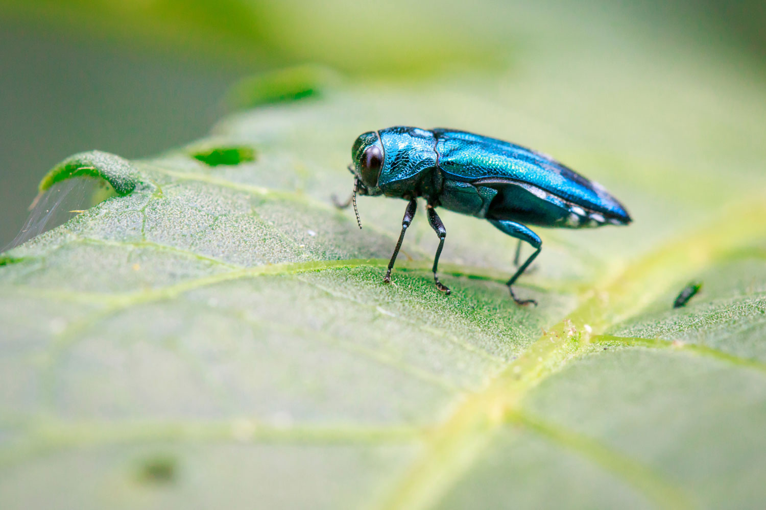
The MN Department of Natural Resources recently released a new grant application to help local governments fund emerald ash borer management in 2023. Each grant cycle is funded a bit differently, may include different eligible activities, and extra priority points on different factors. Occasionally match requirements are waived and the match amount required varies. If you represent a unit of local government OUTSIDE the Twin Cities, this is an excellent opportunity for you since this is the first grant cycle that is awarding priority points for those applicants outside the 7-County metropolitan area.
Who is Eligible?
All units of local government (cities, counties, regional authorities, joint powers boards, towns, tribal
Parks and recreation boards in cities of the first class (those with 100,000 residents or more)
What Activities Are Eligible?
Public tree inventories
Developing a management plan that includes Emerald Ash Borer as a component
Tree and stump removal and replanting
Tree Planting
What is the Timeline?
February 13, 2023 – Application questions due
February 27, 2023 – Applications due
March 20, 2023, Project Selection, Grant Agreement Negotiation begins
July 1, 2023, Work Plans Approved, Contracts Executed, Grant Funded Work begins
How will they Prioritize Funding?
In this grant cycle, priority points will be awarded to:
Applicants outside the 7-County Twin Cities metropolitan area
Communities who have staff, plan to certify their staff during the grant period, or who will contract with companies with staff with professional tree care credentials (MN Tree Inspector, International Society of Arboriculture Certified Arborist, WSB, etc.)
Projects removing and replacing ash trees that pose significant public safety concerns
Projects that benefit underserved populations and areas of concern for environmental justice (communities with higher populations of low-income residents, or people of color including tribal communities or both)
Funding Details
The DNR has a total of $315,000 available in general fund dollars to fund projects managing forest pest and disease with a priority given to EAB on public lands. There is no minimum to the dollar amount applicants can request. The maximum award that will be funded per site is $50,000.
Applicants must include a 25% match of total project funds. The match can be in-kind (such as staff time, to administer the grant, time spent doing removals by in-house crews, technology, equipment used), cash match (such as money spent on ash tree injections by a contractor, re-planting projects by a contractor, or a mix of both. For grantees who are awarded the full $50,000 the match would be approximately $16, 600.
Looking for more information?
For more information on how WSB can help you formulate a project plan and prepare a strong grant application, contact Emily Ball, Forestry Program Manager at 651-318-9945 or eball@wsbeng.com.
Emily is a ISA Certified Arborist, MN Tree Inspector that brings 20 years of experience, primarily in community forestry. She has extensive experience in contract administration, management of staff, AmeriCorps members and contractors, budget and grant management, plan review, tree health and condition inspections, outreach and education. She works closely with partner organizations, staff, and the community to educate, manage natural resources and provide excellent customer service.
January 12, 2023 By Alison Harwood, Director of Natural Resources, WSB
The Environmental Quality Board (EQB), the authority on Minnesota’s Environmental Review program, has released a new required form and process to incorporate climate-related information into the environmental review process. Environmental reviews are required on projects of certain densities, sizes, and/or types and can include Environmental Assessment Worksheets (EAWs), Alternative Urban Areawide Reviews (AUARs), or Environmental Impact Statements.
Prior to 2021, information related to climate change was not part of the environmental review process. A project’s potential to impact the environment focused on resources such as water resources, wildlife, habitat, soils, and noise as well as public infrastructure and transportation. In 2021, several public agencies participated in a pilot program to test the effectiveness of proposed changes to the EAW form that incorporated information related to climate change. Based on the outcome of that pilot project, the EQB voted to replace the previous EAW form with a new one that includes several additions related to climate change assessment and estimating a carbon footprint.
Any projects that required and began an environmental review document after December 14, 2022 are required to use the new form. The new form includes several additions related to climate, including:
Assessment of climate trends related to the proposed project
Evaluation of climate adaptation potential and resiliency of the proposed project design
Evaluation of existing or proposed green infrastructure
Estimation of greenhouse gas emissions/carbon footprint of the proposed project
The EQB has a guidance document available for developing a carbon footprint and incorporating the climate change information into the environmental review process. WSB is available to help navigate this new process and keep your projects on track. Reach out to Alison Harwood with questions.
Alison leads the Natural Resources group. Her experience includes work in the natural resources field, including wetland and avian surveys, permitting, alternatives analysis, and environmental documentation for projects in both the public and private sector.
Late last fall, Congress passed the bipartisan Infrastructure Investment and Jobs Act (IIJA), which infused an astounding $1.2 trillion into our nation’s infrastructure. The package, which includes $550 billion in new federal spending over the next five years, gave local and state governments significant opportunities to fund infrastructure improvements over the next several years, and many communities have already taken advantage of this influx of funding.
Transportation, clean energy, clean water, broadband expansion, and more, gave communities across the country an unprecedented opportunity to invest in projects that will have a meaningful impact on the future for residents, businesses, and the environment.
How Have Communities Benefited from this Funding?
Every community is different, and every community’s needs are different, but here are some of the top ways that local leaders, planners, and governments have benefited from IIJA.
Whether a large metropolitan city or a small rural town, every community has a list of needed infrastructure projects, but funding and resources are often limited. Communities must prioritize, and sometimes put larger projects on the back burner due to budget constraints.
TheIIJA is helping to change that mindset for many communities, giving leaders a greater opportunity to think big. Whether it’s getting on a project funding priority list, putting forward a feasibility plan, or thinking more comprehensively about the environment, transportation, or other community infrastructure needs, the federal infrastructure law has provided meaningful opportunities to secure funding for projects that may have previously been out of reach.
Viewing Projects Through an Equity Lens & Involving More Voices in Community Planning
Equity is a major component of IIJA, creating a real opportunity for communities to invest in projects that benefit traditionally underserved communities, as well as advance sizable projects that create a better community for all. Including equity in infrastructure project planning not only enhances local communities and benefits residents, but it also gives projects a competitive edge in securing dollars from the federal funding package.
Many communities are viewing their infrastructure projects through an equity lens and incorporating more voices as they plan for the future.
Our climate is changing, and “once-in-a-century” storms no longer occur just once in a century. Higher temperatures, drought, more intense precipitation, wildfires, flooding, and changing ecosystems are all issues that impact communities’ infrastructure planning. Building greater resiliency in projects and planning for more extreme weather and climate events is critical and recognized within the IIJA funding.
Green infrastructure, innovative stormwater solutions, water reuse systems, native landscaping, and more can help mitigate risk and better protect populations, native species, and habitats.
Developing Brownfield Sites
Brownfields – previously developed sites that are no longer in use – are underutilized space that present real opportunities for economic, social, and environmental revitalization. However, they are often costly to redevelop. With more than $1.5 billion allocated to brownfields in the infrastructure package, many communities are taking advantage of the opportunity to move forward with brownfield projects, and expand their city’s tax base, grow jobs, build housing, and develop sites in ways that benefit residents and the community at large.
Building a More Sustainable Future
Sustainability is a fundamental component to infrastructure, and IIJA allows communities to invest in forward-looking projects that will have long term, positive environmental and social impacts. From electric vehicle charging stations and energy storage to ecological restoration, greater investment in sustainability is allowing local leaders to make bigger, more thoughtful investments that will help address climate change and resiliency.
Navigating a once-in-a-generation opportunity
Our team of funding experts help communities navigate grant applications, data gathering, project design and engineering, sustainability planning, stakeholder engagement, and more. IIJA is a once-in-a-generation infrastructure investment opportunity, and communities of all sizes can and should tap into the extraordinary opportunity for infrastructure improvement and investment.
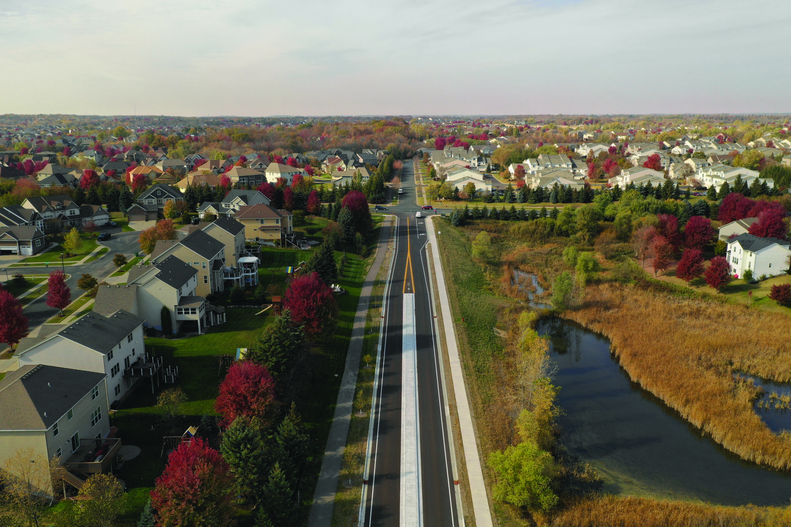
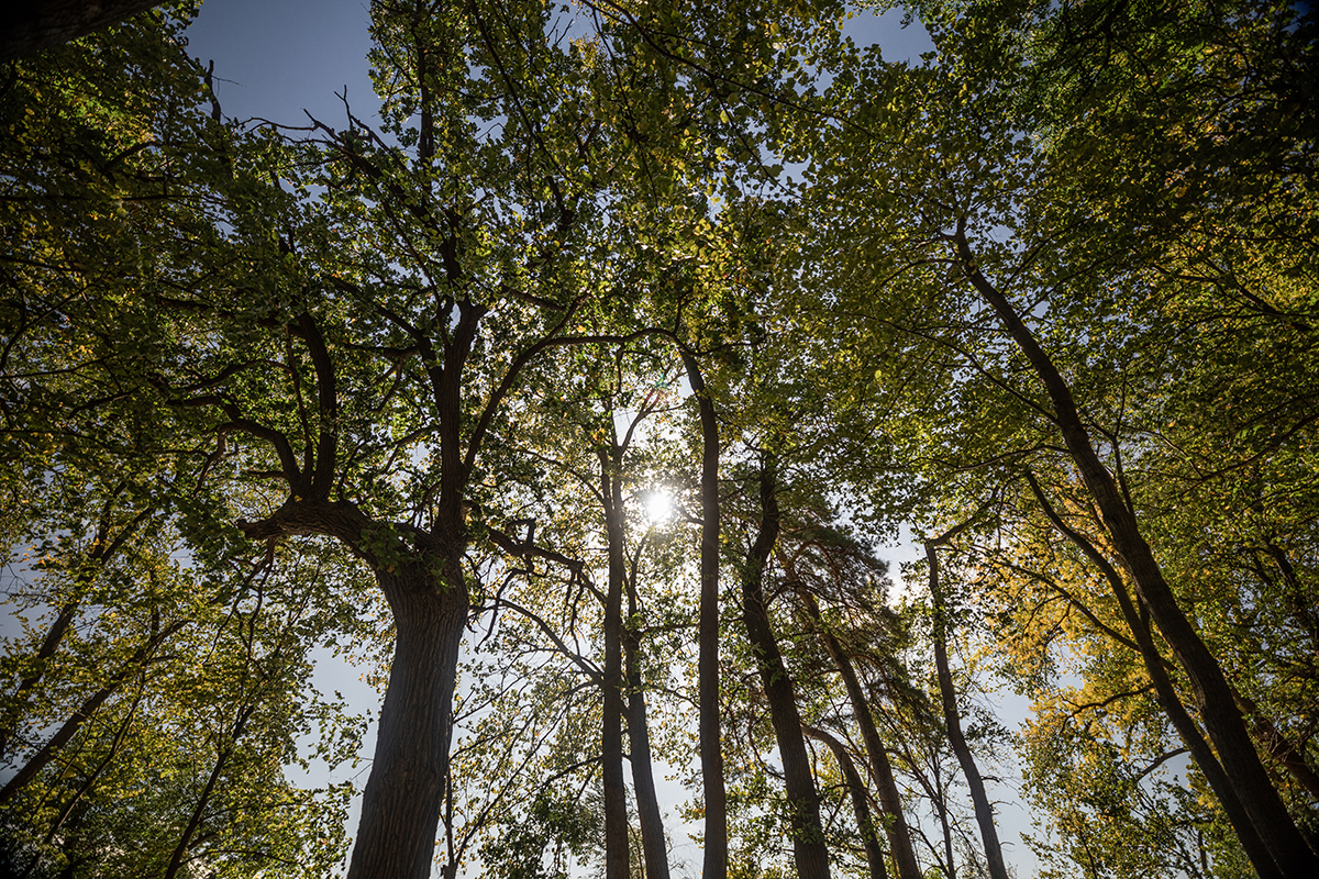
Green infrastructure is a term that has gained momentum recently. It refers to the framework and benefits humans can harness by building, preserving, or maintaining a resilient natural system. Green infrastructure solves some of our most pressing drainage, heat, air, and water quality problems, particularly in areas with the most population. Trees are one of the most vital and effective green infrastructure components that contribute to many cities’ sustainability goals. From stormwater interception and soil conservation to carbon storage and sequestration to improving air quality and reducing heat island effects; tree canopy cover provides many benefits.
Sustainability Goal: Preserve or Increase Canopy Cover
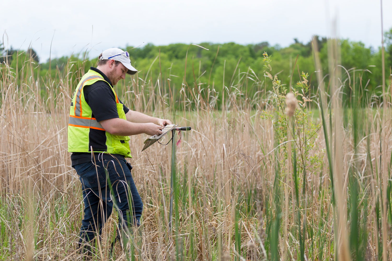
Increasing tree canopy cover over time can have a large impact on a community’s sustainability efforts. To meet that goal, the first step is to understand the current canopy cover and perform a “look back” to examine past trends. To gain an understanding, the USDA Forest Service has a free i-Tree Canopy application that quantifies canopy cover across the community. In the 7-county area of the Twin Cities, communities can use the Metropolitan Council’s “Growing Shade” mapping tool to observe canopy cover and develop goals based on local issues and priorities. Another step is to quantify the number of ash trees in the community through a tree inventory. All ash trees are at a risk of death which will negatively impact canopy cover if not preserved.
Mature shade trees have a bigger canopy so they can capture and store more carbon than their newly planted counterparts. They also provide the most ecosystem benefits – all compelling reasons to preserve what is already established, while also adding new trees. If an inventory has not yet been performed, the community must determine if a statistical sample will be adequate or if a full tree inventory should be performed. Issues related to data collection variables, potential stratification of the city, long-term management and storage of the data must be considered.
This quantification work requires expertise, months of implementation, and often exceeds staff time or budgets designated to accomplish the work. While many communities have planners or sustainability staff, they may lack the expertise that a city forester or an ISA-certified arborist has. Even in a community with a thriving forestry program, managing routine work may be at capacity and carrying out projects like a canopy analysis may not fit into the work plan.
How WSB Can Help
Whether it is achieving a Green Step Cities best practice, part of a larger sustainability or climate action plan, WSB staff are prepared to help you define, preserve, and increase your canopy cover with Forestry, Natural Resource and Sustainability experts. We help our clients assess existing canopy, explore trends, provide an inventory to assess species diversity and resiliency, define the ecosystem benefits that public trees are already providing, and examine tangible steps to preserve existing canopies. With the community’s goals in mind and data, we provide a clear strategy to maximize canopy cover over time.
Emily brings 20 years of experience, primarily in community forestry. She has extensive experience in contract administration, management of staff, AmeriCorps members and contractors, budget and grant management, plan review, tree health and condition inspections, outreach and education. She works closely with partner organizations, staff, and the community to educate, manage natural resources and provide excellent customer service.
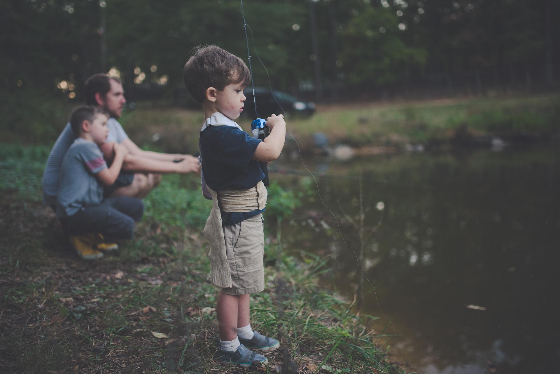
Here in Minnesota, we’re proud to be the land of 10,000 lakes. We have deep ties to water – from its significant cultural importance to native tribal communities to the “Up North” summer tradition of boating, fishing, swimming, and enjoying lake life.
But no matter if you’re in Minnesota or anywhere across the country, the health of our waters – from drinking water to recreational water – is critical to our environment, to wildlife, and to ensure that we can enjoy our time on the water today and preserve it for future generations.
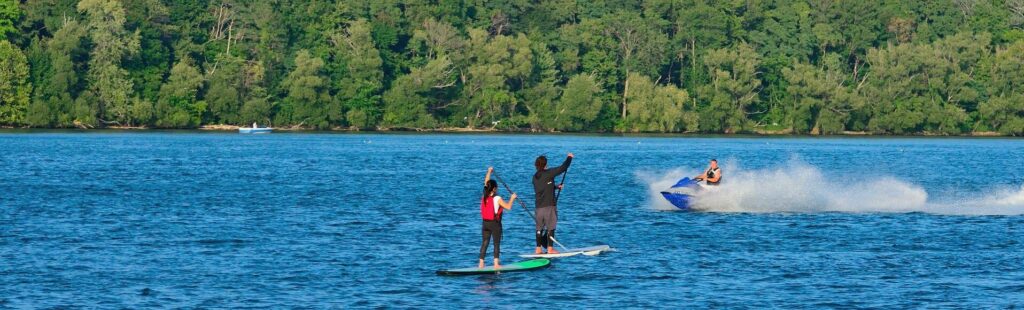
What are Recreational Waters?
People tend to have different ideas when defining recreational waters. Some instantly think of swimming, while others jump to fishing, kayaking, or boating. Recreational waters can include rivers, lakes, streams, and wetlands.
When the government talks about waters, they designate them into categories including drinking water, agriculture, industrial, or navigational use. Within each designated use area, there are water quality standards, which can be measured numerically or narratively, that determine whether the water is fit for its designated use or impaired.
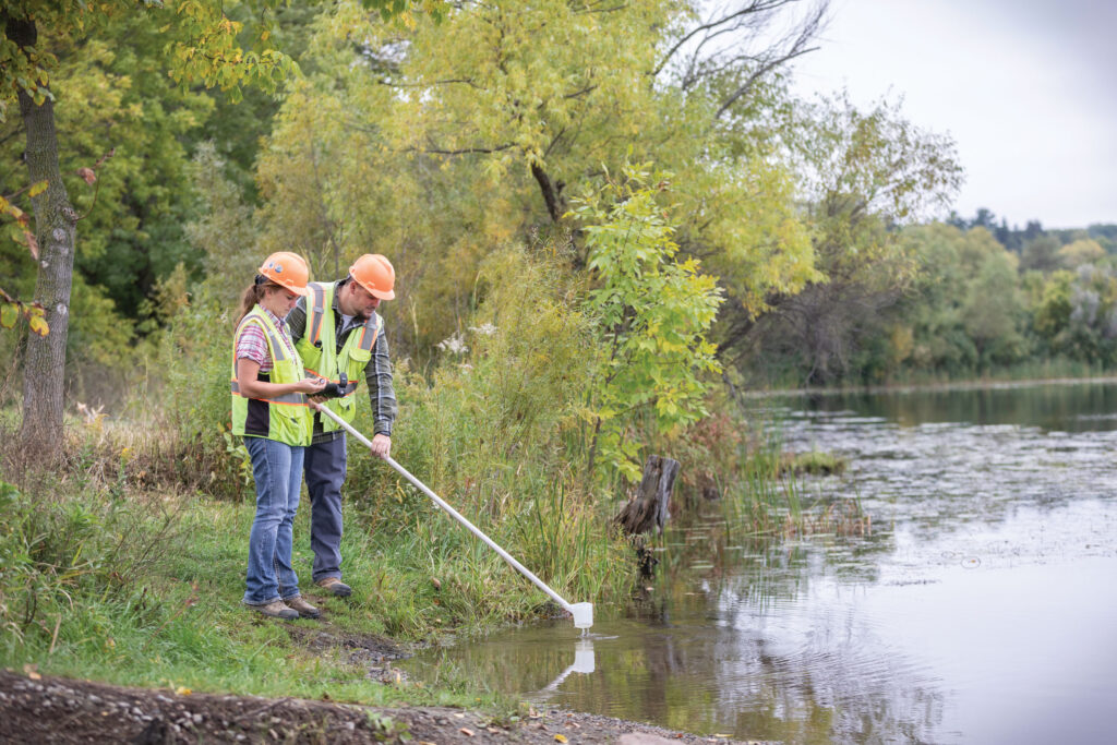
Monitoring Water Quality
Entities at all levels manage and maintain our waters, from federal and state agencies to municipal governments, to non-profit organizations, to local groups like residential lake associations.
When evaluating a body of water’s quality for its intended use there are three main categories that can characterize the water: the water’s chemical, physical, and biological characteristics. Cities or other local entities checking water quality typically focus on measuring phosphorous, chlorophyll-a, and secchi depth since there are numerical standards developed for comparison as well as other indices which can provide additional understanding of the quality of a specific body of water with regard to these chemical characteristics.
From there, it is determined if a water body is impaired and what remedies need to be applied.
Issues Facing Recreational Waters
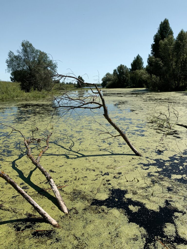
There are a number of issues that can impact the health of our waters. Some are man-made, and others are caused by climate and weather changes.
For those on the lake this summer, algae blooms are often one issue that pops up when the weather gets warm. Algae blooms occur when there is an elevated concentration of phosphorus. Too much algae can reduce water visibility and quality. Furthermore, when blue-green algae becomes too concentrated in lakes, it can be toxic to humans, dogs, and other animals.
Invasive species are also an issue for recreational waters, and are often caused by people moving plants, dirt, and/or animals into new habitats. Zebra mussels have proven to be a problem when they colonize the bottom of lakes. Their sharp shells can puncture skin and are a risk to those swimming. Phragmites australis, one of the most invasive plant species in North America, can grow tall in shallow waters, interrupting kayaking and other water activities.
Climate change, and more extreme weather events, can also impact the health of water. High rainfall, for example, can elevate a water body to unsafe levels, flooding local communities, damaging properties, or making the water body unsafe for swimming, boating, and other activities due to contaminants in run off.
How Partnership & Collaboration Will Help Protect Recreational Waters
With so many different entities, government organizations, and nonprofits working to protect and monitor our waters, partnership is key. Greater collaboration can better protect our waters and help meet water quality goals that benefit everyone. Many grant funding opportunities exist to aid entities and partnerships interesting in improving and addressing water quality and conservation.
Only one percent of Earth’s water is fresh and available to humans, making it an incredibly precious resource. We must all work together to protect it, so we can enjoy it today and for generations to come.
Havranek has nearly 20 years of experience in the natural resources field. Prior to his time at WSB, Tony helped develop federal policies with the U.S. Fish and Wildlife Service and worked with tribal communities throughout the Midwest on their natural resources needs. He is recognized throughout the industry for his forestry, water quality, fisheries, aquatic and terrestrial vegetation, wetlands and wildlife expertise.
Design work is taking place this year on an exciting project that aims to help people connect with the Mississippi River and nature.
Mississippi Gateway Regional Park, operated by Three Rivers Park District, includes 160 acres of parkland on the western shore of the Mississippi River in the City of Brooklyn Park. Coon Rapids Dam has spanned the river at the location for more than a century; in 1969, Northern States Power Co. gave the dam and 225 acres of surrounding land to what became Three Rivers Park District to establish a regional park on the Mississippi. Three Rivers operates the park on the west side of the river; Anoka County Parks and Recreation owns and operates Coon Rapids Dam Regional Park on the eastern side of the river in the City of Coon Rapids.
For five decades, the park has been a staple in the community, attracting visitors from across the Twin Cities region. Although the park is one of the most unique in the Three Rivers Park District system, it had not undergone significant investment in several years. To revitalize the park and to build better connections with the surrounding communities, in 2017 Three Rivers Park District embarked on developing a new vision for the park.
Nestled just across the road from the park is the city of Brooklyn Park’s Environmental Nature Area, a space full of opportunities to connect with nature. With the parks located adjacent to each other and only separated by West River Road, Brooklyn Park and Three Rivers Park District realized that they could provide better service to residents and park guests by working together.
The agencies developed a joint park master plan to avoid duplication and to provide a greater array of offerings for the public. Combining the park with the nature area would allow for a broader recreational experience for users. The planning process purposefully targeted equity markets that have historically been underrepresented in the visitor base for nature-based parks: minorities, non-English speaking households, new immigrants, low-income households, and people ages 45+. Throughout the master planning process, the project team engaged community residents in many ways – at community events, cultural gatherings and through user groups. The public identified features and amenities that became the basis of the vision for the park. This process made it possible for the park to truly reflect the priorities and values of the people who use it, and the resulting master plan described how together the two parks could be combined to create Mississippi Gateway Regional Park. In December 2020, Three Rivers and the City of Brooklyn Park formalized their partnership by approving a cooperative agreement to design, construct and operate Mississippi Gateway Regional Park.
“This project is the most significant capital investment in a park in the Park District’s history, and it fits perfectly with Three Rivers Park District’s vision that every person can connect with nature every day,” said Three Rivers Park District Commissioner Jennifer DeJournett, whose district includes the park. “Mississippi Gateway will welcome all individuals, whether they’re new to Minnesota or have been here for generations and will offer free and affordable programs to encourage everyone to explore the outdoors.”
With a comprehensive redesign of both areas, and a number of planned new features, the new park was born. Mississippi Gateway Regional Park will bring the vision to life: to connect the community, families, and residents to nature. To develop a strong vision that would cement this iconic park’s legacy, Three Rivers Park District and the city of Brooklyn Park consulted with WSB, a Twin-Cities headquartered design and consulting firm. Through a robust public engagement plan, master planning and design services, a vision and strategy to update the park for current and future generations to enjoy was created.
Connecting New Audiences with Nature
At the heart of this project are people. The goal is that people of all abilities and cultures have access to a fun, welcoming park where they can connect with and explore nature and the river in many ways. The location of Mississippi Gateway Regional Park provides a unique natural environment within the diverse, urban area where it lies. For children and adults alike, parks are a place to learn, exercise, grow and celebrate all Minnesota has to offer.
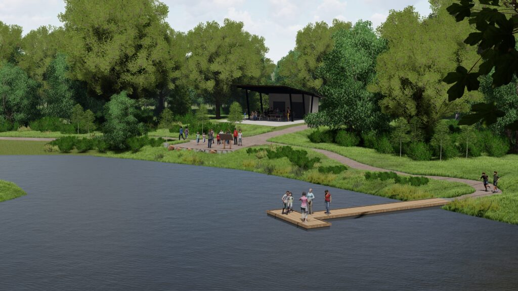
A major natural feature of the park is the Mississippi River and the unique landscape and habitats that surround it. People may come to the park for a variety of reasons, but all are drawn to the beauty and power of the mighty Mississippi that forms the natural eastern border of the park.
The park means something different to every user, and it will remain a significant landmark that is safe, accessible, convenient, unique and fun for those looking to experience the beauty and wonder of nature and the Mississippi close to where they live.
Commissioner DeJournett added, “We anticipate that the new Mississippi Gateway Regional Park will be a jewel of both the Three Rivers and Brooklyn Park systems and will be a favorite place for residents of the Twin Cities Metro Area as well as visitors from Greater Minnesota and around the country to connect with the Mighty Mississippi and enjoy the outdoors.”
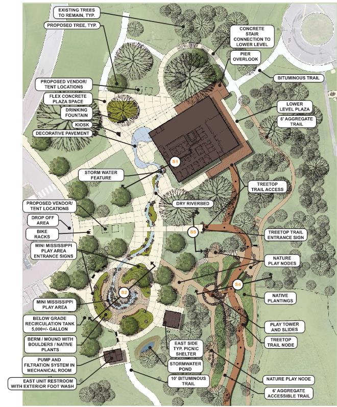
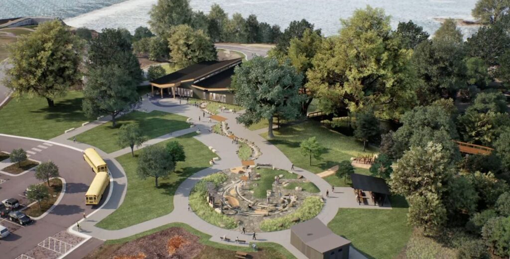
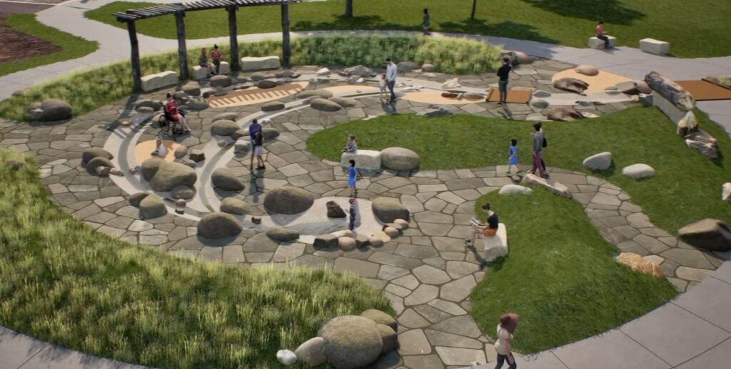
What’s Coming to Mississippi Gateway Regional Park
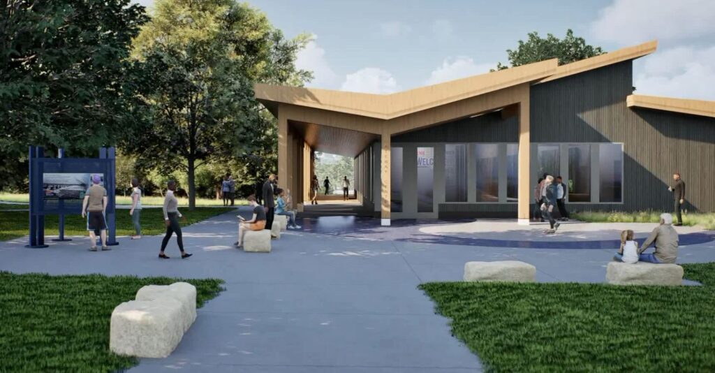
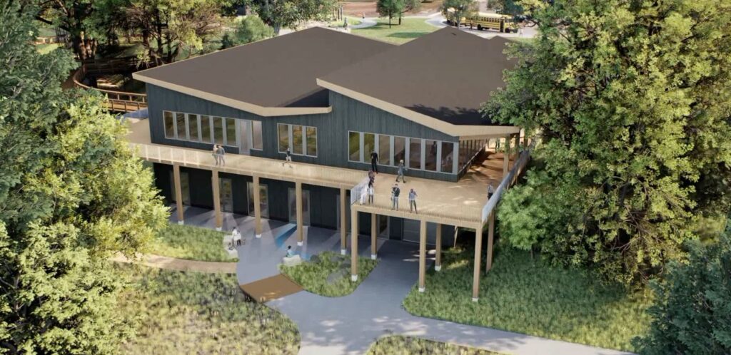
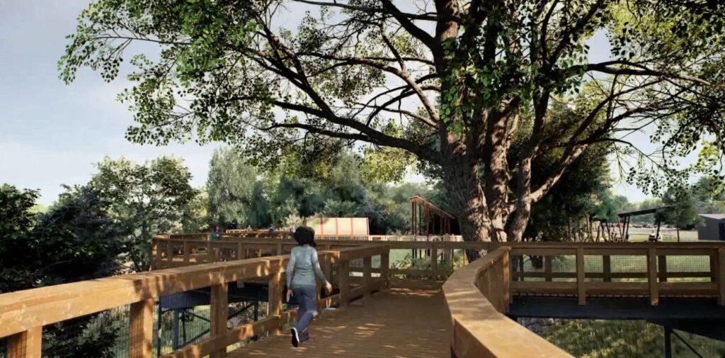
Meaningful updates and one-of-a-kind experiences will attract visitors and provide significant benefit to the community and region. A new Gateway Center building will offer exhibit areas with learning opportunities focused on the Mississippi River and the park, classroom areas for school groups and park programming, and a space for equipment rentals, allowing further exploration of the park through the use of snowshoes, skis or bikes. A treetop trail, which will be an elevated walkway through the canopies of existing mature trees, will be developed near the Gateway Center. In addition, a nature-themed play tower and nature play nodes will connect to the treetop trail to create exciting play opportunities for all abilities. During the design process, staff from Three Rivers and WSB are engaging with students from Champlin-Brooklyn Park Academy for Math and Environmental Sciences to garner students’ input on the design of the nature play features. A “Mini-Mississippi” interactive water feature will provide a unique opportunity for users to access a stream channel, get their feet wet and manipulate the flow of water to further understand the dynamics of a river. These elements will provide unique perspectives, hands-on experiences, and exciting play opportunities for everyone to explore nature.
Beyond the core development area, Mississippi Gateway Regional Park will provide enhanced trails, gathering places and shelters, nature connection nodes and additional accessible fishing opportunities along the edge of the river. The western part of the park will also include a reservable shelter, playground, off-leash dog area, and an enhanced archery range.
Even with all the planned renovations, keeping a natural feeling in the park is still an achievable goal. The focus will remain on creating accessible opportunities to connect with the natural environment. Native plantings will be included with the restoration efforts throughout the park, while other proposed elements will be nestled within the existing vegetation and terrain.
Throughout the master planning, schematic design and design development phases of the project, the design team was careful to provide solutions that are equally engaging in all seasons of the year. The treetop trail and other trails are designed for year-round use, while cross-country ski and snowshoe trails also weave throughout the landscape.
This is an exciting project that will continue to connect the community with nature. The project is currently transitioning into the construction document phase of design, with a grand opening targeted for 2026. Mississippi Gateway Regional Park will be an inviting, welcoming and vibrant place for everyone to discover nature and the Mississippi River.
Jeff is a landscape architect with over 21 years of professional experience. He has worked on projects of various scales and scope both in private and public sectors. He has significant experience as a project manager directing installations and overseeing project implementation. His experience has led to creative design solutions which acknowledge varied user perspectives by collaborating with private developers, landowners, and business owners, as well as municipal staff. He embraces collaboration to ultimately bring the original vision into functional reality.
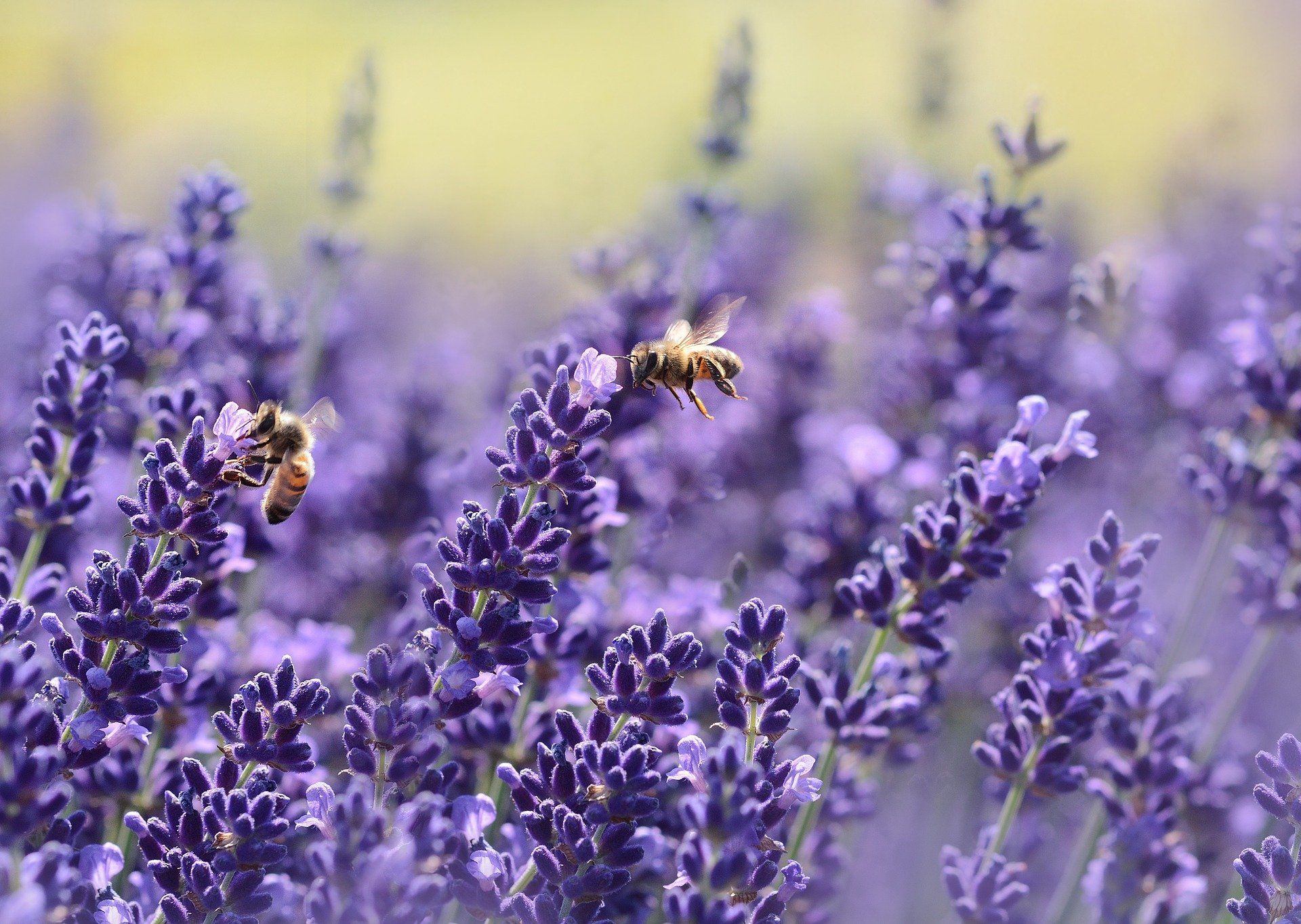
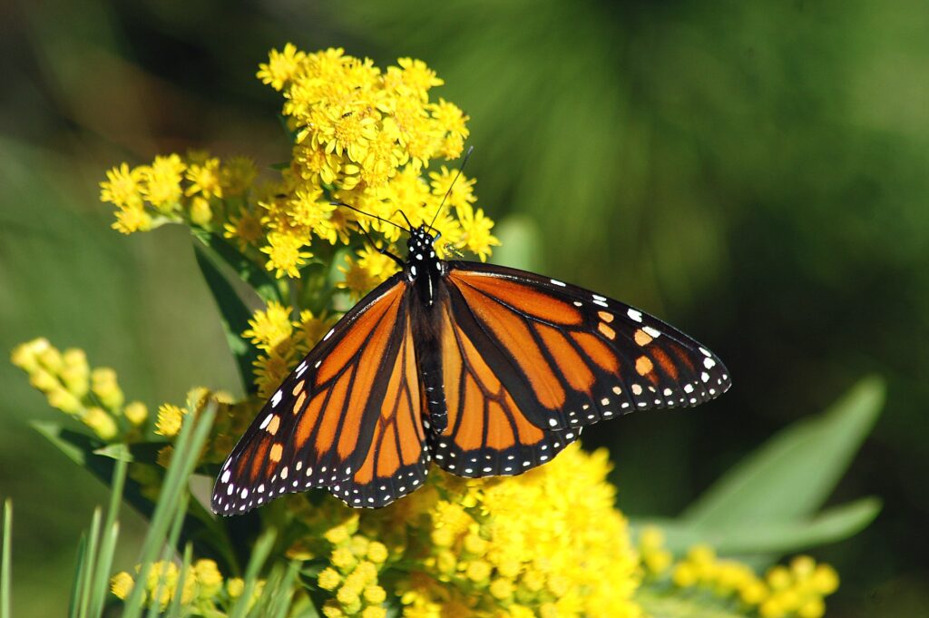
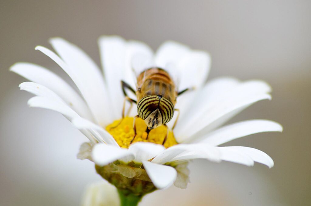
Over the past few decades many populations of pollinating species (such as butterflies and bees) in the U.S. have declined significantly due to invasive pests and diseases, pesticides, herbicides, loss of habitat, and climate change. Due to these declines, efforts are being made to conserve, restore, and maintain habitats that are valuable to pollinators. These efforts include the University of Illinois-Chicago (UIC) led Candidate Conservation Agreement with Assurances (CCAA) for the monarch butterfly (Danaus plexippus) and the CCAA/Safe Harbor Agreement (SHA) for bumble bees that is currently in development.
Monarch Candidate Conservation Agreement with Assurances (CCAA)
The Monarch CCAA was finalized in April 2020. Since then participation and interest in the program from the energy and transportation sectors has grown with 20 energy and 15 transportation applicants throughout the U.S., thus far.
The Monarch CCAA program has been very successful. More than 815,000 adopted acres have been committed, of which more than 692,000 acres are under an active CCAA; far surpassing the adopted acres target of 215,000 acres.
If you are interested in applying for the Monarch CCAA, please note that a decision regarding the status of the monarch is expected in 2024. If the monarch is listed as threatened or endangered, no new Monarch CCAA applications will be accepted following its listing.
Bumble Bee CCAA/Safe Harbor Agreement (SHA)
Building on the success of the Monarch CCAA, the UIC and USFWS are exploring the creation of a companion agreement aimed at conserving habitats for six listed or petitioned for listing bumble bee species in North America. The Bumble Bee CCAA/SHA may be extended to cover six additional species in the future.
The proposed Bumble Bee CCAA/SHA would provide similar protections as those in the Monarch CCAA, thereunder an approved CCAA/SHA would allow for incidental take of species covered under the agreement for 25 years. With the updated USFWS rusty-patched bumble bee guidance and rulings of listing status for many bee species expected in 2024, the protection of incidental take permit would be valuable. Also, if the program is successful, some bumble bee species may not need to be listed.
There are 49 bumble bee species in the U.S. Since 2017, two have been listed as federally endangered. Most recently, four have been federally petitioned to be listed, five are at risk, and one was considered unwarranted for listing although it has experienced significant population declines. These 12 species comprise approximately 25 percent of the bumble bee species in the U.S. (Table 1). Species that are at risk, but not currently petitioned to be listed may be petitioned in the future if their populations continue to decline.
Table 1. Bumble bee species being considered for coverage under the Bumble Bee CCAA/SHA and their respective ranges in the United States.
Species
Status
Range
Rusty patched bumble bee Bombus affinis
Federally endangered
From Minnesota to Missouri and to the east coast.
Franklin’s bumble bee B. franklini
Federally endangered
California and Oregon.
American bumble bee B. pennsylvanicus
Federally petitioned
Most of lower 48 states. Assumed to be extirpated from Oregon and Washington.
Variable cuckoo bumble bee B. variabilis
Federally petitioned
From the Midwest to the east coast and Colorado and Arizona.
Western bumble bee B. occidentalis
Federally petitioned
Western U.S.
Suckley’s cuckoo bumble bee B. suckleyi
Federally petitioned
Most of western U.S. and Alaska.
Yellow bumble bee B. fervidus
At risk, but not petitioned for listing
Western, Midwestern, and north-eastern portions of the U.S.
Cuckoo bumble bee B. bohemicus (formerly ashtoni)
At risk, but not petitioned for listing
Northern half of the lower U.S. and Alaska.
Obscure bumble bee B. caliginosus
At risk, but not petitioned for listing
California, Oregon, and Washington.
Southern plains bumble bee B. fraternus
At risk, but not petitioned for listing
East of the Rocky Mountains through the Great Plains region and east to New Jersey and central Florida.
Crotch’s bumble bee B. crotchii
At risk, but not petitioned for listing
California.
Yellow-banded bumble bee B. terricola
Not warranted
Current range is not known. Most recent records are from Wisconsin and Pennsylvania. Possibly extirpated from other states where it historically occurred.
Source: Nationwide CCAA for Monarch Butterfly (February 2022) Proposal for a Bumble Bee-Focused Combined Conservation Agreement.
Similarities and Differences between Monarch CCAA and Bumble Bee CCAA/SHA
Where Bumble Bee CCAA/SHA adopted acres overlap with Monarch CCAA adopted acres, the following measures are likely to overlap: the implementation and verification of conservation measures used, targeted herbicide application, timed mowing, and idle-habitat set-asides. Additional measures that will likely be required for these areas include the use of bee-preferred seed mixes, invasive species prevention, and the avoidance of commercial bee management.
Further comparisons between the Monarch CCAA and the Bumble Bee CCAA/SHA are provided in Table 2.
Table 2. Comparison of various aspects between the Monarch CCAA and Bumble Bee CCAA/SHA.
Aspect
Monarch CCAA
Bumble Bee CCAA/SHA
Enrollment
Enrolled acres, including adopted acres.
Commitment areas near known locations.
Tracking net benefit
Track conservation measures and adopted acres.
Verify conservation measures used in mapped commitment areas.
Monitoring
Assess milkweed and nectar plant presence.
Assess flowering plant cover and diversity.
Reporting
Annual report describing sum of adopted acres, implementation, monitoring, changes, and challenges.
Will be like the Monarch CCAA except for sum of commitment acres. Tracking will be simplified, monitoring protocol will be different, and reporting will be separate.
Section 7 compliance
Tiered approach to verify that actions avoid and minimize take to avoid impacting other listed species.
Maintain consistency with the Monarch CCAA. Currently exploring additional Section 7 consultation for listed species.
Source: Nationwide CCAA for Monarch Butterfly (February 2022) Proposal for a Bumble Bee-Focused Combined Conservation Agreement.
Looking for more information?
Interested in learning more or getting involved in these programs? WSB natural resources staff are actively involved in these programs and have helped multiple entities through the Monarch CCAA application process and beyond.
Lucas has over 15 years of experience in wildlife ecology and consulting. His specialties include providing desktop and field-based wildlife services for wind and solar projects and has supported the successful completion of these projects in 34 states.
With more and more businesses setting comprehensive sustainability goals that include net-zero carbon emissions, many are unsure what is the best way to achieve those goals or what renewable energy investment will be most effective. Sustainability investment should be data driven and can be done in a way that both protects the environment and a business’ bottom line.
WSB and iD8 have partnered to create a new one-of-a-kind analysis – Renewable Energy Match – that provides clients with a full understanding of renewable energy options, and comprehensive data analysis to drive financial-based decision-making. It goes beyond traditional energy evaluation by combining economic data with place-based environmental information.
Explore clean energy options that meet your needs.
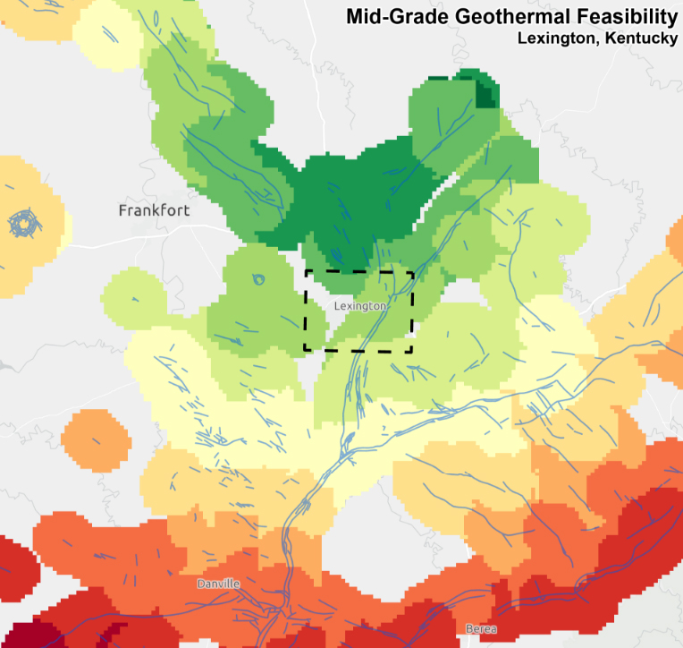
Many companies exploring clean energy solutions often first look to solar and wind energy. Those are excellent renewable energy sources, but there is also untapped potential in sources like hydrogen, geothermal energy, and renewable natural gas.
Every organization has different needs when it comes to renewable energy, so a plan that is customized to individual needs, takes into account location, and is driven by thorough research and data is critical.
How Renewable Energy Match works.
Most companies base their renewable energy decisions off financial feasibility. WSB has taken that concept further and developed a 4-phase approach to determine which renewable energy option is best for each specific client. The process includes:
First-order feasibility study This first step provides a high-level geospatial analysis of the area the client is operating within to determine what resources are available for renewable energy production. It includes iD8 financial assessments for each energy form and an overall optimization for each energy. A risk assessment of external factors that could influence the performance of energy sources is also part of this phase.
Strategic Planning This stage provides a deeper exploration of local energy resources that are available, as well as their acquisition costs, parcel ownership, local energy grids, climate analysis, and more.
Final Design & Regulatory Planning Once the strategic plan is complete, infrastructure planning and design, environmental and resource assessments, and land permitting can begin.
Energy implementation The final phase is to begin energy production and implementation at the selected facility.
Who can benefit from Renewable Energy Match?
There are many types of businesses and organizations that can benefit from Renewable Energy Match including companies with net-zero goals, businesses with multiple facilities or campuses, universities, utilities, and companies looked to expand their energy renewable energy portfolios..
This one-of-a-kind analysis allows clients to strategically explore the costs, sources, and options around renewable energy on a digital platform, and advance investments that will best meet the needs of a client from both an economic and sustainability perspective.
Want to learn more about Renewable Energy Match? Check out our website to explore more, contact a WSB expert, or schedule a demo.
THE CASE FOR PROTECTING AND ENHANCING FRESHWATER INFRASTRUCTURE.
By Luke Lunde, Professional Soil Scientist and Amy Anderson, Project Engineer, WSB
Rivers and streams are a dynamic mixture of water, sediment, aquatic organisms and riparian vegetation. The form of rivers and streams change over time as erosion, accumulation and conveyance of sediment occurs.
Rural and urban surface water runoff and pollution make rivers and streams among the most degraded ecosystems, leading to impaired water quality, biological condition and aquatic habitat. Restoration involves returning a stream or river to a natural shape and condition, so it is well suited to convey water and sediment supply from the watershed.
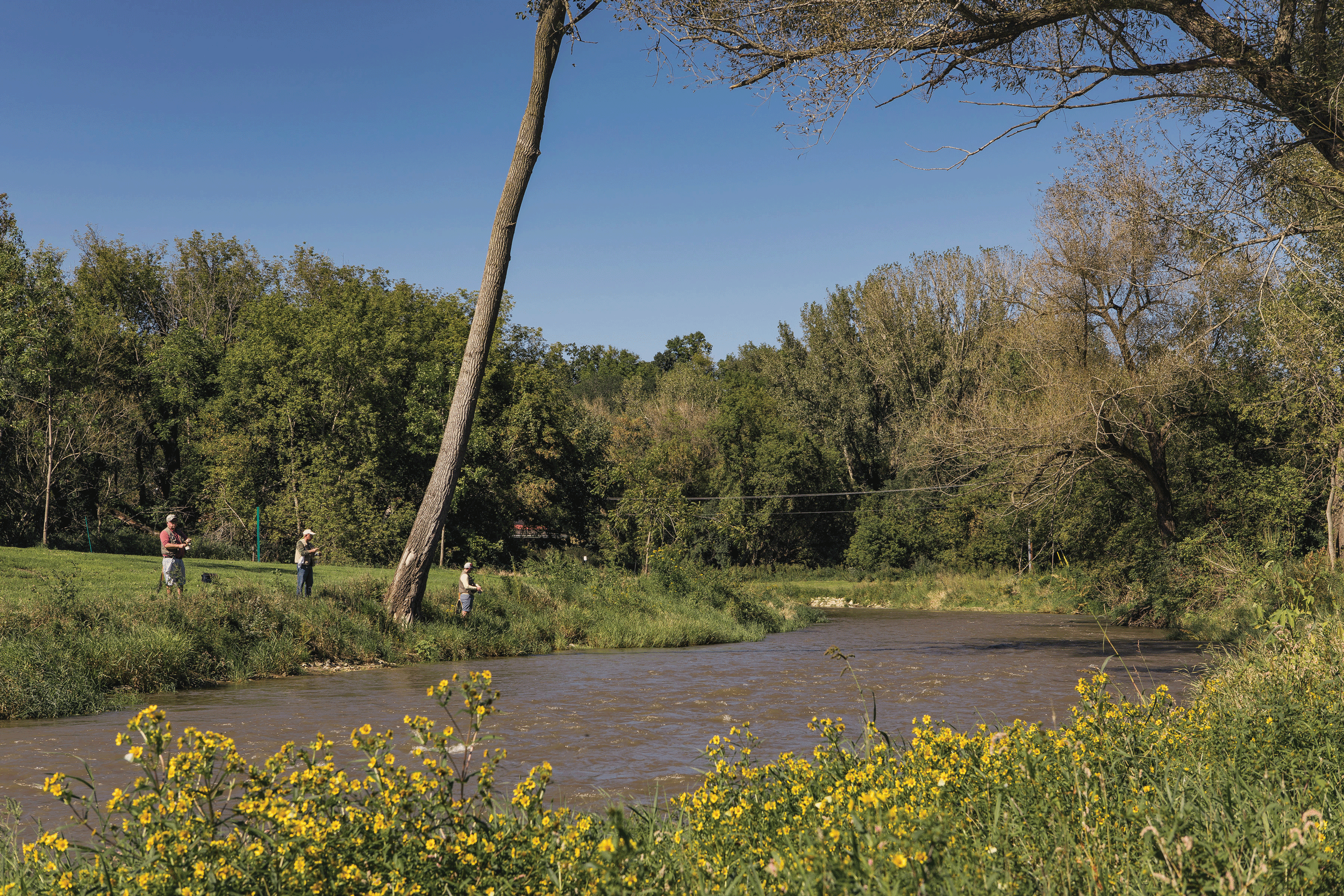
Restoration projects take many forms and encompass many goals, but three of the most common are to improve water quality, mitigate habitat loss to protect fish and wildlife, and increase the public’s ability to use the channel for fishing and other recreational activities.
Along the way, people access rivers and streams as a means of transportation, hydroelectric energy, recreation and more. We rely heavily on rivers and streams as a water source. That’s why keeping them healthy is so important through watershed protection and restoration.
An added benefit of protection and restoration is that it contributes to sustainability. Rivers and streams provide spaces for water to flow in the event of severe weather like a flood. Communities that have well-maintained channels that have connections to its floodplain have built resiliency into their infrastructure systems so they’re more prepared when faced with extreme weather events.
We work closely with our clients on restoration projects that result in an improved habitat for people, animals and fish populations not only at a project site, but further downstream as well. When the protection and enhancement of water quality is considered as part of a watershed approach or a community’s larger infrastructure planning, the benefits are numerous.
IMPROVE WATER QUALITY
Rivers and streams are important public resources, and the quality of the water in them may determine how they can be used. Many areas along rivers and streams have highly erodible banks. Erosion causes nutrient loading to the river or stream, and when these nutrients are transported downstream, they impact water quality throughout the entire system.
When we improve water quality, we reduce loss of riparian habitat and protect aquatic wildlife living in and around rivers and streams, including fish, insects and plants. Taking actionable steps towards improvement results in an increase of aquatic wildlife populations or species diversity. Improving water quality and habitat make an already valued water resource even more valuable to the public.
MITIGATE HABITAT LOSS
Rivers and streams are critical habitat for wildlife, both in and out of the water. Erosion can make riverbanks unstable and decrease water quality and clarity. Stabilizing stream banks addresses these issues. During a recent restoration of the North Fork of the Zumbro River in Wabasha County, MN, we installed a toe wood structure along the riverbank to create an in-stream habitat for both fish and the aquatic insects to improve access to their food source. The toe wood structure will help maintain and enhance game fish populations and stabilize eroded streambanks.
INCREASE ACCESSIBILITY
Wildlife and people must be able to access rivers and streams to make use of them. By addressing water quality and mitigating habitat loss, accessibility is improved. Now, wildlife can utilize a restored, sustainable aquatic resource while at the same time improving public use for fishing, hunting, swimming and other recreational activities.
Luke Lunde Luke is a Minnesota Professional Soil Scientist in WSB’s Environmental Natural Resources Group, and he has over nineteen years of natural resource and environmental review experience. Luke’s experience includes soil survey mapping, geologic hazard assessments, karst feature mapping and mitigation plans, wetland delineation, wetland banking, wetland mitigation, habitat restoration, invasive species management, grant writing, erosion control compliance site management, habitat restoration, invasive species management, natural resource planning, environmental permitting and compliance, for numerous projects throughout the Midwest.
Amy Anderson Amy has over nine years of professional experience in water resources engineering, specializing in stream restoration and watershed management. Amy’s experience in stream restoration spans the project cycle, from surveying and design through construction observation and post-project monitoring. Amy has been the primary author or co-author of Surface Water Management Plans for two separate municipalities (West St. Paul and North St. Paul) and one watershed district (Valley Branch Watershed District) in the metro area and has presented to citizen’s groups, municipal committees, and city councils on surface water management and planning.
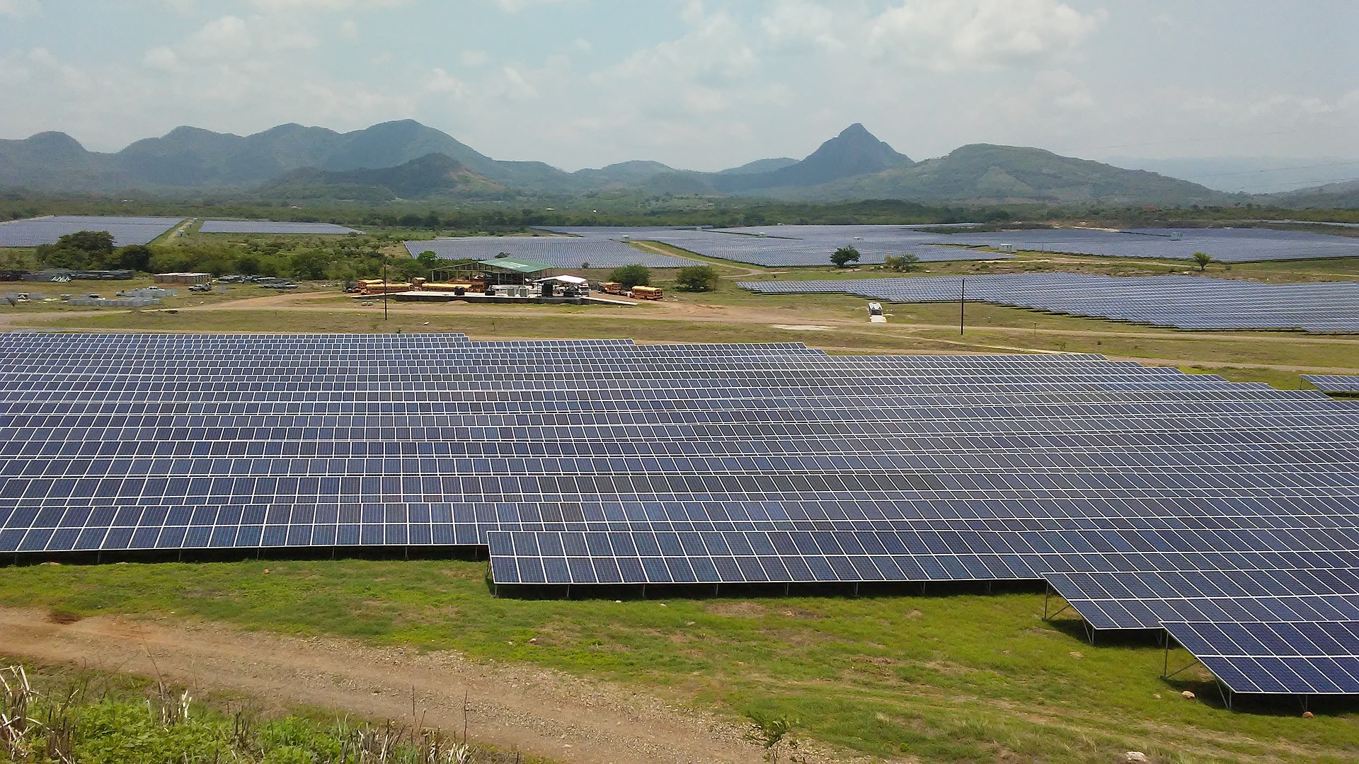
Although it is well-known that wind-energy projects have need for wildlife services, it is less known that wildlife services provide value for utility-scale solar projects. Wildlife services may be needed at different phases of project development depending on state guidelines. State permits, project off-takers or financiers often require wildlife assessments for utility-scale solar projects. Learn more about what you need to be aware of at each stage of a project.
Desktop
Biological assessment or site characterization study
A biological assessment or site characterization study is recommended to identify biological resources that may be impacted by the project including wildlife and fish communities, sensitive habitats, special status species and their habitats, and special management areas. The information gained from biological assessments and site characterization studies can help determine if additional field studies for special status species or sensitive habitats or special status species desktop-level habitat assessments are recommended, and guide project layouts.
Pre-Construction
Raptor nest and eagle nest surveys
Raptor nests, including those of eagles, are protected by the Migratory Bird Treaty Act (MBTA) and eagle nests are further protected by the Bald and Golden Eagle Protection Act (BGEPA). If project construction is planned during the nesting season, it is recommended that raptor nest surveys be conducted. The nesting season varies based on region with earlier start dates in the south. Also, raptor nest surveys are typically conducted prior to leaf-on to locate nests easier. Below are two examples of the need for such surveys.
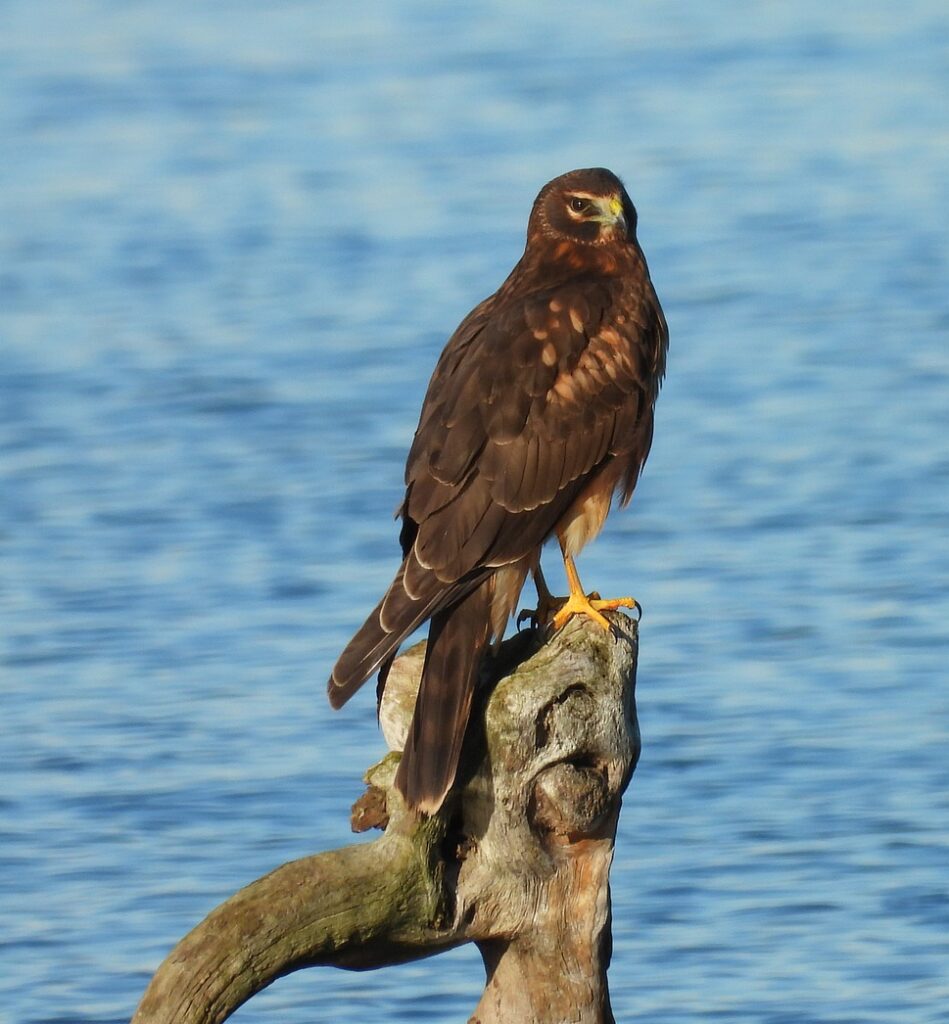
Northern Harrier
Although many raptor species nest in trees, some species such as the northern harrier (Circus hudsonius) nest in herbaceous areas. The northern harrier is state listed in many states, and some states such as Ohio require nesting surveys when construction activities occur in herbaceous areas during the nesting season.
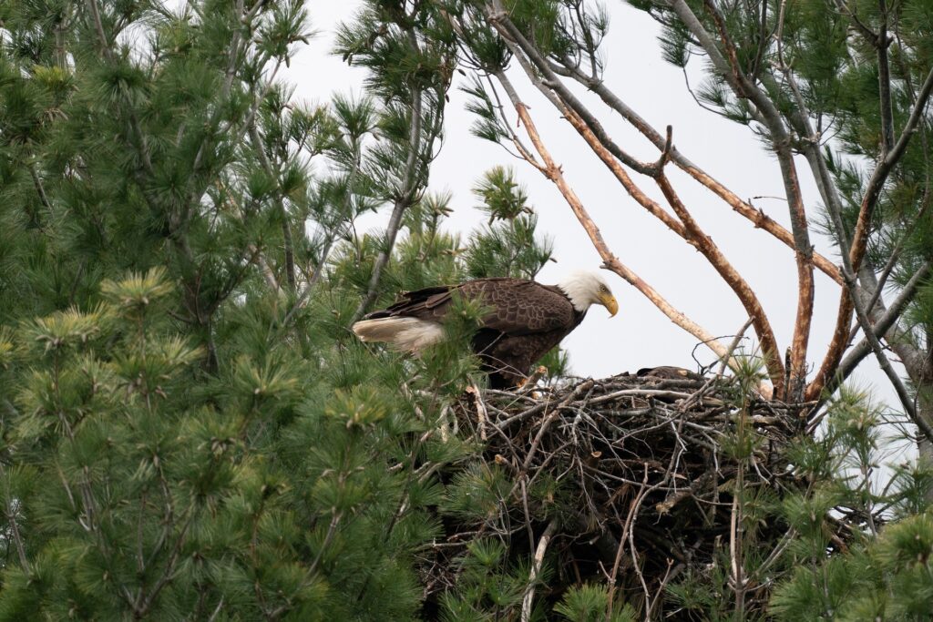
Bald and Golden Eagles
Bald (Haliaeetus leucocephalus) and golden (Aquila chrysaetos) eagle nests have additional protective measures and guidance under the BGEPA. The U.S. Fish and Wildlife Service guidance recommends a no disturbance buffer of at least 660 feet surrounding the nest, whether the nest is active or an alternate nest, unless similar activity occurs closer to the nest. If similar activity occurs closer than 660 feet from the nest, a no disturbance buffer of the same distance as the activity can be used. As the process to remove an eagle nest is long and costly, an eagle nest survey can help identify if there are any in the area that could be avoided during the site design process or during the construction process.
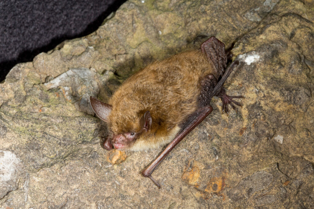
Bat habitat assessment
Many bat species roost in trees during their respective active seasons; some of these species are protected at the state or federal level. As such, tree removal within the ranges of protected bat species requires measures to avoid or minimize adverse impacts or incidental take. Avoidance or minimization measures include removing trees outside of the protected species’ active seasons, conducting habitat assessments to determine if the trees are potentially suitable roost sites, presence/probable absence surveys, or in some instances tree removal is entirely prohibited. Bat habitat assessments are often conducted when tree removal is proposed to occur during the active seasons (April 1 to October 31) of the federally endangered Indiana bat (Myotis sodalis) and the federally threatened northern long-eared bat (Myotis septentrionalis). The ranges of the Indiana bat and northern long-eared bat extend throughout much of the eastern United States. Some states, such as Missouri, have additional guidance measures that need to be followed regarding tree removal within the range of federally listed bat species. The bat habitat assessment provides information used to determine where tree removal can occur and whether tree removal can occur during the active season, or if tree removal activities should be postponed. Bat habitat assessments can be conducted at any time of the year.
During Construction
Environmental Compliance
Bird nest surveys may be needed depending on the geographic region of the project, construction timing, and the habitat types where construction activity will occur. The nests of bird species are protected by the MBTA. Nesting surveys are recommended if construction activities are planned to occur in non-agricultural areas during the active nesting season. The active nesting season varies based on region with nesting activity starting earlier at southern latitudes. If active nests are observed during survey efforts, a no disturbance buffer is established until the offspring are fledged or the nest is abandoned. The size of the buffer depends on the species, with smaller buffers used for nest of common species and larger buffers used for nests of rare species and raptors.
Conclusion
Ultimately, understanding the resources within and near your project site early in project development can reduce the risk of costly design revisions as well as the risk for permitting or construction delays. Although the focus of this piece was on avian and bat-related services for utility-scale solar projects, wildlife services can also help with project-related concerns involving other taxonomic groups including invertebrates (such as the rusty patched bumble bee [Bombus affinis] and Dakota skipper [Hesperia dacotae]) and reptiles (such as the eastern massasauga rattlesnake [Sistrurus catenatus] and Blanding’s turtle [Emydoidea blandingii]). For additional questions regarding the need for and value of wildlife surveys, contact Lucas Wandrie.
Lucas has over 15 years of experience in wildlife ecology and consulting. His specialties include providing desktop and field-based wildlife services for wind and solar projects and has supported the successful completion of these projects in 34 states.